Showing: 1 - 5 of 5 RESULTS
Blogs California Palm Springs

10 Best Hikes in Palm Springs

From lush oases to challenging peaks, here are the best hikes near Palm Springs!

Contents

Note: This post may contain affiliate links, meaning I get a commission if you decide to purchase something through the links, at no additional cost to you.

Whether you’re a seasoned hiker seeking a challenge or a casual adventurer looking to connect with nature, Palm Springs has a hike to suit your preferences. The surrounding mountains and canyons provide a plethora of hiking opportunities for outdoor enthusiasts of all skill levels. As a desert native and a hiking enthusiast, these are actually my top ten best hikes spanning across the entire Coachella Valley, not just in the city of Palm Springs. But, most people who aren’t from the desert, don’t recognize the name Coachella Valley, they are only familiar with where Palm Springs is so I decided to name the blog as such. Anyway, happy hiking!

Araby Trail

3.4 Miles | 1,200 ft. Elevation Gain | Rated Moderate | Out & Back
Address: 2049 Rim Rd, Palm Springs, CA 92264

There’s a small parking lot by Rim Road adjacent to a mobile home park. Please note that the trailhead isn’t actually in the mobile home park even though maps often make it look like it is. You will however, hike alongside it at the very beginning.

Araby Trail is definitely one of the most favored trails in the city of Palm Springs. Hikers are treated to breathtaking views of the surrounding mountains and a unique glimpse of the Bob Hope House, an architectural marvel. The trail is pretty much all uphill, covering a fair amount of elevation gain in just 1.7 miles, so be prepared, I definitely wouldn’t consider it an easy climb.

Tahquitz Canyon

1.9 miles | Elevation gain 324 ft | Out & Back | Easy
Address: 500 W Mesquite Ave Palm Springs

Tahquitz Canyon offers a perfect outing for families seeking a quick adventure. This easy to moderate hike takes you along ancient rock formations to a 60-foot waterfall payoff. Although it’s family-friendly, furry companions must stay home. Keep in mind the $15 per person fee ($7 for children aged 6-12) as it’s considered sacred land, owned by the Cahuilla Indians. An annual pass is available for $125. You also have to be 18 or older to enter the canyons alone. The park operates from Oct. 1 to July 4 from 7:30 a.m. to 5 p.m. daily (with the last hiker allowed on the trail at 3:30 p.m.).

Find more information on hours, pricing & information to know before you go, here:
https://www.tahquitzcanyon.com

Murray Canyon to Seven Sisters Falls

3.7 Miles | 538 ft. Elevation Gain | Rated Moderate | Out & Back
Trailhead: 2019 E Murray Canyon Dr, Palm Springs, CA 92264

Murray Canyon is located in the Indian Canyons between Palm Canyon and Andreas Canyon in the city of Palm Springs. The starting point of the trail is located at the same developed trailhead used for accessing Andreas Canyon. You may however, drive a short distance further into the picnic areas, which will trim a little less than 0.4 miles off the roundtrip distance. Please note that Indian Canyons does require an access fee, as it’s also considered sacred land, owned by the Cahuilla Indians. General admission for adults is $12.

Find more information on hours, pricing & information to know before you go, here:
https://www.indian-canyons.com/hours

This hike guides you along an easy desert terrain, offering views of sweeping vistas before leading you into the canyon where you’ll hike alongside a stream. The trail does cross over the stream multiple times, but for the most part, you shouldn’t get wet as there are rocks and logs guiding you over the water. I do recommend sturdy hiking boots or water shoes if you’re concerned about getting wet though. In the canyon, you’re also surrounded by lush vegetation and unique flora & fauna. The waterfall at the end of the trail is a wonderful payoff. Unlike the Tahquitz Canyon, 60-foot waterfall, Seven Sisters is much smaller and a bit tucked away, but still beautiful and refreshing.

If you’re looking for more hikes and ways to explore Indian Canyons, check out my blog, Your Guide to Exploring Indian Canyons in Palm Springs, Ca

Art Smith Trail

6.0 Miles | 1,200 ft. Elevation Gain | Rated Moderate | Out & Back
Address: Roy Wilson Memorial Hwy, Palm Desert, CA 92260

The full Art Smith trail is a total of 16.2 miles and is considered challenging. But, if you’re looking to experience the beauty of this hike without committing to the full 16.2, consider doing Art Smith to the first oasis. It’s about 6 miles round trip, covering approximately 1,200 ft. total of elevation gain, leading to a small palm oases (shown below in the last image). The trailhead can be found off Highway 74,  about 1/4 mile past the Bighorn Country Club. The best times to visit this trail are September through May. You’ll need to leave pups at home โ€” dogs aren’t allowed on this trail.

La Quinta Cove to Lake Cahuilla

6.3 Miles | 912 ft. Elevation Gain | Rated Moderate | Out & Back
Address: 54990 Avenida Madero, La Quinta, CA 92253

Park at the unpaved lot located at the intersection of Avenida Bermudas and Calle Tecate. Follow the Cove Oasis Trail for 0.67 miles before turning left (you’ll see a Cove to Lake Trail sign). The first section of the trail is very flat but be prepared to walk aways in sand. As the trail progresses, expect moderate elevation changes. Hikers will experience stunning views of the Santa Rosa mountains and the nearby Quarry Golf Course. Eventually, the trail leads you to Lake Cahuilla, a small reservoir open for recreational fishing and camping.

East Indio Hills Badlands

5.2 Miles | 777 ft. Elevation Gain | Rated Moderate | Lolipop
Address: Golf Center Pkwy, Indio, CA 92203

Located at the eastern end of Avenue 42nd and the northern end of Golf Center Parkway in the city of Indio, the East Indio Badlands Trail offers a 5.2-mile loop showcasing a diverse array of geological formations, desert vegetation, and panoramic vistas of the Coachella Valley. The hike begins along the edge of the Terra Lago Resort Golf Course and leads you into a slot like canyon. Once out of the slots, you’ll experience a small accent with a nice payoff overlooking the entire desert. This trail is also very dog-friendly!

Palm Springs Aerial Tramway to San Jacinto Peak

10.1 Miles | 2,578 ft. Elevation Gain | Rated Challenging | Out & Back
Address: 1 Tramway Rd, Palm Springs, CA 92262

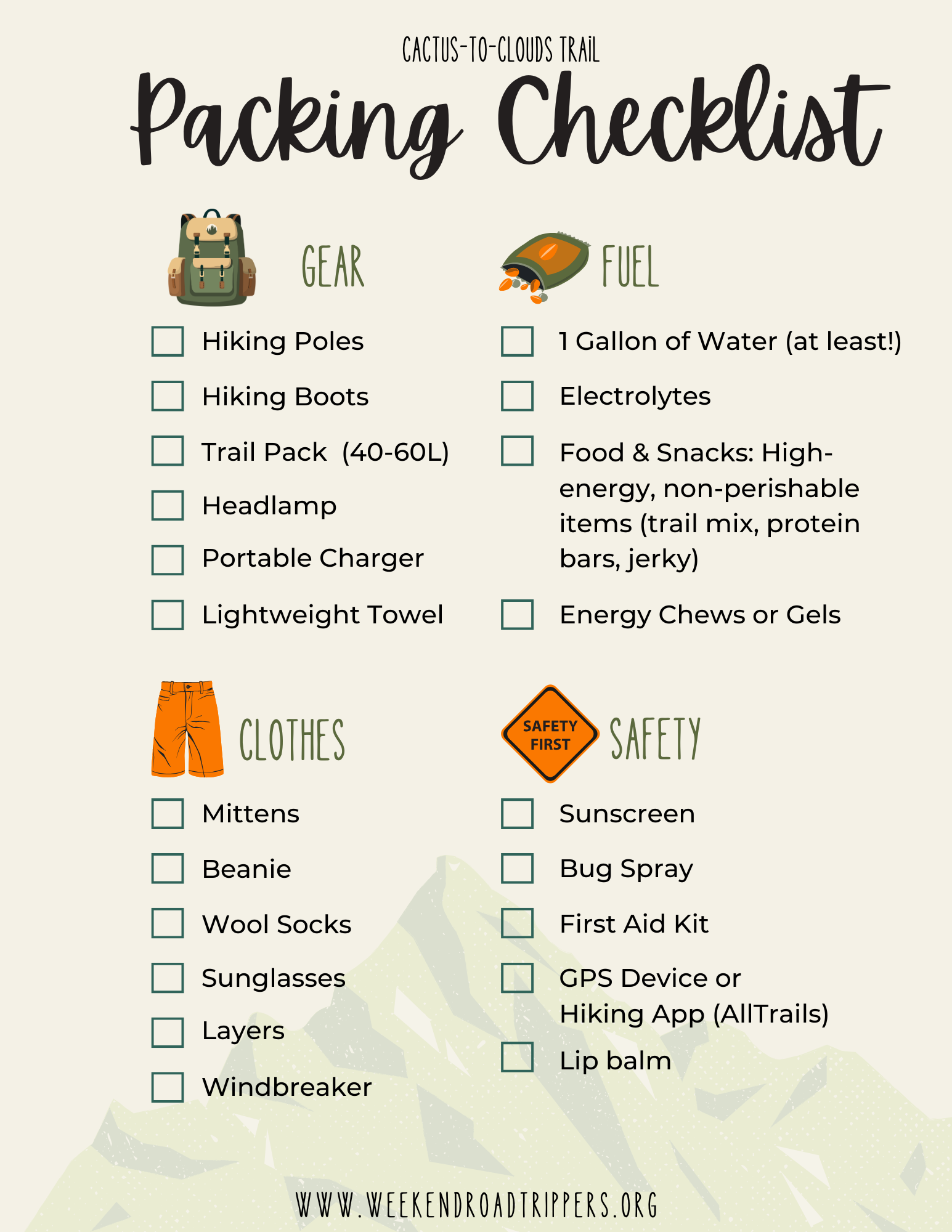
Begin your journey by driving to the Palm Springs Aerial Tram. Purchase your tram ticket and prepare for an exhilarating ride to the summit! The tram itself is a great experience, boasting the World’s Largest Rotating Tramcar. The Palm Springs Aerial Tramway travels over 2.5 miles up to the Mountain Station at 8,516 ft in just 10 minutes. The temperature at the Mountain Station is also 30 to 40 degrees cooler than the valley floor.

Once you make it up to the top of the tram, your next journey begins. The hike to San Jacinto Peak is 10.1 miles, out & back, covering 2,578 ft. of elevation gain. It’s no easy feat. The best times to visit this trail are March through November but check the weather conditions because depending on the winter, March may still be very snowy, with late storms blowing in. Also be sure to acquire a permit. Day-use permits can be obtained on the day of your trip by visiting the ranger station, which can’t be missed because you must past the ranger station to continue on the correct trail route.

The Bump and Grind Trail

4.0 Miles | 1,099 ft. Elevation Gain | Rated Moderate | Loop
Address: Painters Path, Palm Desert, CA 92260

The Bump-n-Grind Trail in Palm Desert is arguably the most popular hiking trail in the desert for locals looking for a good workout. The hike is known for its challenging incline and breathtaking views of the Coachella Valley. It’s a 4-mile loop that gains about 1,000 feet in elevation, making it a quick but intense workout (usually around 1 hour, depending on your fitness level).

Coachella Valley Preserve McCallum Trail

1.8 Miles | 95 ft. Elevation Gain | Rated Easy | Out & Back
Address: 29200 Thousand Palms Canyon Rd, Thousand Palms, CA 92276

This an easy 1.8 mile, out & back trail that’s great for kids and family! This trail features numbered stops providing insight into the surrounding fan palms, the San Andreas Fault, desert pupfish, and other geological and ecological wonders of the preserve.

For those looking for more information on the Coachella Valley preserve or other hiking trails to explore there, check out my blog, Exploring the Coachella Valley Preserve.

Palm Desert Cross Hike Loop

3.2 Miles | 764 ft. Elevation Gain | Rated Easy | Loop
Address: 72500 Thrush Rd, Palm Desert, CA 92260

The Palm Desert Cross has definitely become a local landmark and one of the most popular hikes. It’s a fairly easy accent and it is dog-friendly. You can either do it as an out& back journey, turning it into about a 2.2 mile hike, or you can do the loop, extending it about an extra mile. The loop also takes you down to another hidden gem, the Yin Yang mural.

Honorable Mentions

  • Mission Creek Preserve – Desert Hot Springs
  • South & North Lykken Trail
  • Randall Henderson Loop – Palm Desert

Favorite areas just outside of the Coachella Valley

  • Whitewater Preserve
  • Ladder Canyon/Painted Canyon
  • Joshua Tree National Park
  • Morongo Valley Preserve

Whether you’re an avid hiker looking to conquer Cactus-to-Clouds or just looking to get out in nature at the Coachella Valley Preserve, I hope this round-up has helped you navigate your next adventure. Happy hiking my friends!

Blogs California Palm Springs

Your Guide to Hiking Cactus-to-Clouds

WHAT IS CACTUS-TO-CLOUDS?

Cactus-to-Clouds is a 21-mile assent from the Palm Springs valley floor, starting at about 400 feet, up to the San Jacinto Peak at 10,834 feet. It is rated one of the hardest day hikes in the United States, and the trail actually has the largest elevation gain out of any hike in the United States. Skyline trail takes you up about 9.4 miles, starting behind the Palm Springs Art Museum and ascending to the top of the Palm Springs Aerial Tramway. Then, to do the full Cactus-to-Clouds hike, you continue for another 11 miles to the peak and back down to the tramway station to ride the tramcar back down to the valley floor.

WHAT TO PACK

Here is a list of everything I packed, with links to a few recommended essential items. I don’t gain any commission on any of these items, this is just exactly what I packed and what I would recommend (as a female hiker).

  • Layers, Layers, Layers – I wore biker shorts and a long sleeve dri-fit with a hat, which was perfect for the heat during the first half of the trek, and then I packed, sweatpants, a hoodie, a light windbreaker, and a larger warm jacket, a beanie, and mittens. By the time I reached the peak, I had every layer on and was so glad I packed it all.
  • Hiking Boots – I always recommend boots with ankle support for long hikes.
  • AT LEAST 1 Gallon of water – I brought three, 1.5 liter SmartWaters. Not the most environmentally friendly I know, but it was the most comfortable and cheap way I could think to pack them all on my back. I also packed four additional 16.9-ounce plastic water bottles that I had pre-prepared with the electrolyte and magnesium tablets ahead of time. I know most hikers use a bladder as well, which is also an option (I, for some reason, am not a huge fan). I packed all of this and still filled up two more of my SmartWaters at the Ranger Station at the top of the tram and completely drank both of those too by the end of the hike.
  • Electrolytes
  • Sunscreen
  • Sunglasses
  • Bug Spray
  • First-Aid Kit – With some sort of compression wrap in case of a sprained ankle or other form of injury)
  • Lip Balm
  • Ibuprofen
  • Headlamp – I started and ended the hike in complete darkness
  • Hiking Poles – These were life savers for my legs
  • Energy Goo or Chews
  • Snacks! – I cut up two protein bars into small bite-size pieces and put them in a baggie to snack on throughout the day. I’d also recommend some sort of salty snack like trail mix, crackers, etc. I also packed a peanut butter and honey sandwich, which is always my go-to trail food. It is recommended to try and eat something small every hour!
  • Hiking Backpack – Make sure it’s large enough to fit everything mentioned above (At least 35L)
  • Phone – With Hiking App (AllTrails)
  • Portable Charger
  • Lightweight Towel or Handkerchief

KNOW BEFORE YOU GO

Aside from what to pack, here’s a few other useful tips/information to consider.

  • Start at the Right Time – It is recommended you start this hike between 12 a.m. and 4:30 a.m. to allow yourself enough time to finish before the last tram car down at 9:30 p.m.
  • Hike During the Right Time of the Year – Fall is really the best season to do this hike so that the temperature isn’t too hot at the beginning and isnโ€™t too cold as you reach the top. Temperatures in Palm Springs are in the triple digits during summer and temperates at the top of the Palm Springs Aerial Tramway are typically around 30 degrees in the winter with plenty of snow.
  • Pack AT LEAST 1 Gallon of Water – There are two rescue boxes along the trail that sometimes contain extra water left behind by other hikers, and you can also fill up at the ranger station at the top of the tramway, but I would definitely not rely on these sources, but they are good to know about beforehand in case of emergency. You will be hiking for many hours and need to be properly hydrated the day before the hike AND during the hike. Also, on that note, carb load the night before. I recommend a pasta night.
  • You Will Need a Permit – You must obtain a permit before continuing on once you reach the top of the tram. The permits are free and located at the ranger station. This not only allows rangers to protect the wilderness but is also meant to keep you safe. With limited cell service in the San Jacinto mountains, permits allow the rangers to know if you’ve safely returned from your hike.
  • Know Where to Park at the Trailhead101 N Museum Dr, Palm Springs, CA, 92262, USA. Do not park in the museum parking lot or the parking garage across the street or you will be ticketed (or worse, towed). There is however, free street parking around the museum with plenty of spots if you start early morning. Also keep in mind, you will be finishing the hike at the parking lot at the bottom of the Palm Springs Aerial Tramway, which is actually around 20 minutes from where you began your journey behind the Palm Springs Art Museum. Be sure to have a plan for how you will get back to your car.

THE ROUTE

Lastly, here are some trail markers that are helpful to know so you can see how far you’ve traveled and how many miles you still have left to go!

I hope this blog helps anyone out there looking to cross this beast of a hike off their bucket list. Happy hiking!

Blogs California Other California Deserts

9 Unusual Things to Do Near Joshua Tree

Located in Southern California in the Mojave Desert, Joshua Tree is a haven for outdoor enthusiasts and is home to one of the three entrances to Joshua Tree National Park. While the natural beauty of the area is undoubtedly breathtaking (and typically the main draw), there’s a quirky and unconventional side to Joshua Tree waiting to be explored. If you’re looking for more to do during your trip than just visit the national park, here are 9 unusual and capitivating places to check out!

1. Pioneertown

Take Highway 62, to Yucca Valley and then turn left on Pioneertown Road. Then, in about 15 minutes, you will have arrived in a completely different era. Pioneertown is an Old West themed town that was originally build in the 1940s’ as a movie set but has since evolved into a tourist attraction with gift stores, boutique shops, restaurants, events and more! Stay at the iconic Pioneertown Motel, and be sure to end an evening at the infamous Pappy & Harriets!

2. Pappy & Harriets

No visit to Pioneertown is complete without experiencing the unique charm of Pappy & Harriets. This legendary desert roadhouse, is a beloved music venue and restaurant. Renowned for its rustic atmosphere, live music performances, and mouthwatering barbecue, Pappy & Harriets is a must-visit destination.

3. Joshua Tree Saloon

Quench your thirst and satisfy your taste buds at the Joshua Tree Saloon. This iconic watering hole is a western themed bar located in the city of Joshua Tree. They offer good drinks, all your favorite comfort foods, and live music!

4. World Famous Crochet Museum

This adorable little museum showcases a collection of crocheted wonders that will leave you in awe. The World Famous Crochet Museum is located at 61855 Highway 62, Joshua Tree, just east of the Joshua Tree Saloon. The Museum is free and open 24/7. The owner, Shari has been collecting crochet items since the early 1990s, years before she decided to purchase this roadside hut that now houses her collection!

5. Noah Purifoy Outdoor Desert Art Museum

Noah Purifoy Outdoor Museum is a 10-acre museum with sculptures made completely out of junk. It can be found off the beaten path, at 62975 Blair Lane in the city of Joshua Tree. Admission & parking are FREE!

6. The Beauty Bubble Salon & Museum

For a dose of nostalgia and vintage charm, visit the Beauty Bubble Salon & Museum. Step into a time capsule where the walls are adorned with classic beauty salon artifacts and memorabilia. This hidden gem is not just a museum, it’s actually still an operating hair salon!

7. The Station

The Station is an 1949 service station that has been transformed into a gift shop where you can find, souvenirs, t-shirts, jewelry and more. Also, The Station, Beauty Bubble and the World Famous Crochet Museum are all within walking distance of each other! I’d recommend hitting these three spots together first, before journeying to the other locations mentioned in this blog.

8. The Transmission Sculpture

“Transmission Sculpture” by South African sculptor Daniel Popper, sits at the Mojave Ranch in Joshua Tree. The face is 32 feet tall and the hands each measure 27 feet tall!

9. Smith’s Ranch Drive-In Theater

And last, but certainly not least, Smith’s Ranch! Experience the magic of a movie only available in theaters but watch it under the starry desert sky. Smith’s Ranch is the only operating drive-in movie in the area. Pack your snacks, grab a blanket, and enjoy a movie night from the comfort of your car!

Beyond the famous national park, Joshua Tree hides a treasure trove of unconventional attractions. From crocheted wonders to outdoor art installations, historic movie sets, and the legendary Pappy & Harriets, these unusual gems add a touch of quirkiness to your desert adventure. Embrace the unexpected and embark on a journey that goes beyond the ordinary in the heart of Joshua Tree.

Looking for places to stay near Joshua Tree National Park? Read here!

View deals on Tripadvisor

Blogs California SoCal Mountain Towns

Hiking Castle Rock Trail in Big Bear, California

2.7 miles | Elevation gain 826 ft | Max Elevation of 7,401 ft | Out & back | Rated Moderate

Address: Castle Rock Trail 1W03, Big Bear Blvd, Big Bear Lake, CA 92315

Castle Rock Trail, located in Big Bear, California, is a 2.7-mile roundtrip hike and one of the most popular trails to explore in the area. Reaching the peak rewards hikers with breathtaking panoramic views of the expansive Big Bear Lake and its picturesque surroundings. While the hike is considered moderately difficult, the stunning vistas make the trek well worthwhile.

Directions & Parking

After passing the Big Bear Dam en route to Big Bear City, the road takes a little U-turn inland. This is where you’ll find Castle Rock Trail. It’s important to note that parking can be challenging. The only parking is small shoulder along the side of the highway that requires you park and then cross the busy street to get to the trailhead. With limited parking space, you may have to park at a different turn out and walk a bit along the highway. Once you cross the street, you’ll be greeted with a map that details the trails in and around the area.

The Trailhead

Near the map, you’ll also see you will see the sign for Castle Rock, noting that the official trailhead. The elevation in Big Bear paired with immediately climbing a heavy accent up the mountain, KICKED MY BUTT. Since it’s only a little over a mile to reach the top, it’s a tough but quick climb in my opinion. The path is also guided by what I thought appeared to be quite literally little castle rocks along the way to keep you going in the right direction.

As you begin to catch glimpses of Big Bear Lake, you’ll encounter numerous smaller side trails. Keep an eye out for the stone markers and use them as your guide to explore these additional paths.

The Peak

The pinnacle of the hike is the Castle Rock peak. The peak is a large rock formation (a castle rock I suppose is what it’s meant to resemble) where hikers are rewarded with a 360-degree panorama that includes the San Bernardino Mountains, the Mojave Desert, and on clear days, even glimpses of the San Gabriel Mountains in the distance.

Tips for Hikers

  1. Seasonal Considerations: While the trail is open year-round, be aware that snow can accumulate in winter, requiring proper equipment for a safe hike. Spring and fall offer milder temperatures, making these seasons ideal for a more comfortable experience.
  2. Pack Essentials: Bring plenty of water, snacks, and sunscreen. Wear sturdy hiking boots and dress in layers, as temperatures can vary throughout the day.
  3. Leave No Trace: Practice responsible hiking by leaving no trace. Pack out all trash and follow the “leave no trace” principles to preserve the natural beauty of the trail.

Now get up and head to Big Bear. Happy Hiking!

Blogs California Orange County

48 Hours in Newport Beach, California

Hey there, fellow seekers of weekend bliss! Newport Beach, tucked away on the Californian coast, is such a great spot for a relaxing 48-hour getaway. With its serene beaches, coastal charm, and diverse offerings, Newport has all the ingredients for an epic escape. As someone who was born and raised in Southern California, I grew up going to Newport Beach often. Our family would rent a beach house for a week in the summers and now as adult, I still find myself there for plenty of weekend trips. So, here is my ultimate laid-back guide on how to make the most of your time in this coastal haven.

Day 1: A Walk to Remember

Morning: Ease into your day with a calming stroll along Newport Pier. Inhale the fresh ocean air and savor the panoramic ocean views. Stop by Newport Coffee Company for coffee, aรงaรญ bowls and pastries!

Late Morning: Head over to Balboa Fun Zone for a touch of nostalgia and leisure. Enjoy classic arcade games, take a ride on the Ferris wheel, and treat yourself to the local favorite โ€“ the Balboa Bar, a frozen banana dipped in chocolate and various toppings.

Afternoon: Lunchtime calls for a visit to the historic Cannery Seafood of the Pacific. With its waterfront setting, diverse menu, and harbor views, it’s a perfect spot to unwind. Follow up with a relaxing harbor cruise to take in the scenic beauty of Newport Harbor.

Evening: Transition into the evening with a visit to Fashion Island, Newport’s premier shopping destination. Explore high-end boutiques, savor a waterfront dinner, and cap off your night with a movie at the stylish Island Cinema.

Conclude your day with a serene sunset stroll along the Newport Beach Boardwalk.

Day 2: Adventure Time!

Morning: Kick off your second day with an active morning exploring the Newport Back Bay on rented bikes. The scenic trails offer stunning views of the estuary and a chance to connect with nature. Follow it up with a beachfront brunch at The Beachcomber Cafรฉ at Crystal Cove, offering a true Californian experience.

Afternoon: For an afternoon filled with adventure, try paddleboarding or kayaking at Newport Harbor. Rentals are readily available, allowing you to soak up the sun while enjoying the water. Refuel with a casual lunch at Bear Flag Fish Co., renowned for its fresh fish tacos and poke bowls.

Late Afternoon: Wind down at Corona del Mar State Beach, where you can relax on the sand or explore the nearby tide pools at Little Corona Beach for a unique coastal encounter.

Evening: Cap off your weekend with a visit to Lido Marina Village. Browse through trendy boutiques, appreciate local art, and enjoy a gourmet dinner at Nobu Newport Beach, known for its fusion of Japanese and Peruvian flavors.

Newport Beach offers the perfect blend of relaxation and adventure for a delightful 48-hour escape. Whether you’re into coastal tranquility, culinary delights, or outdoor exploration, it’s a great destination to explore. Happy traveling!