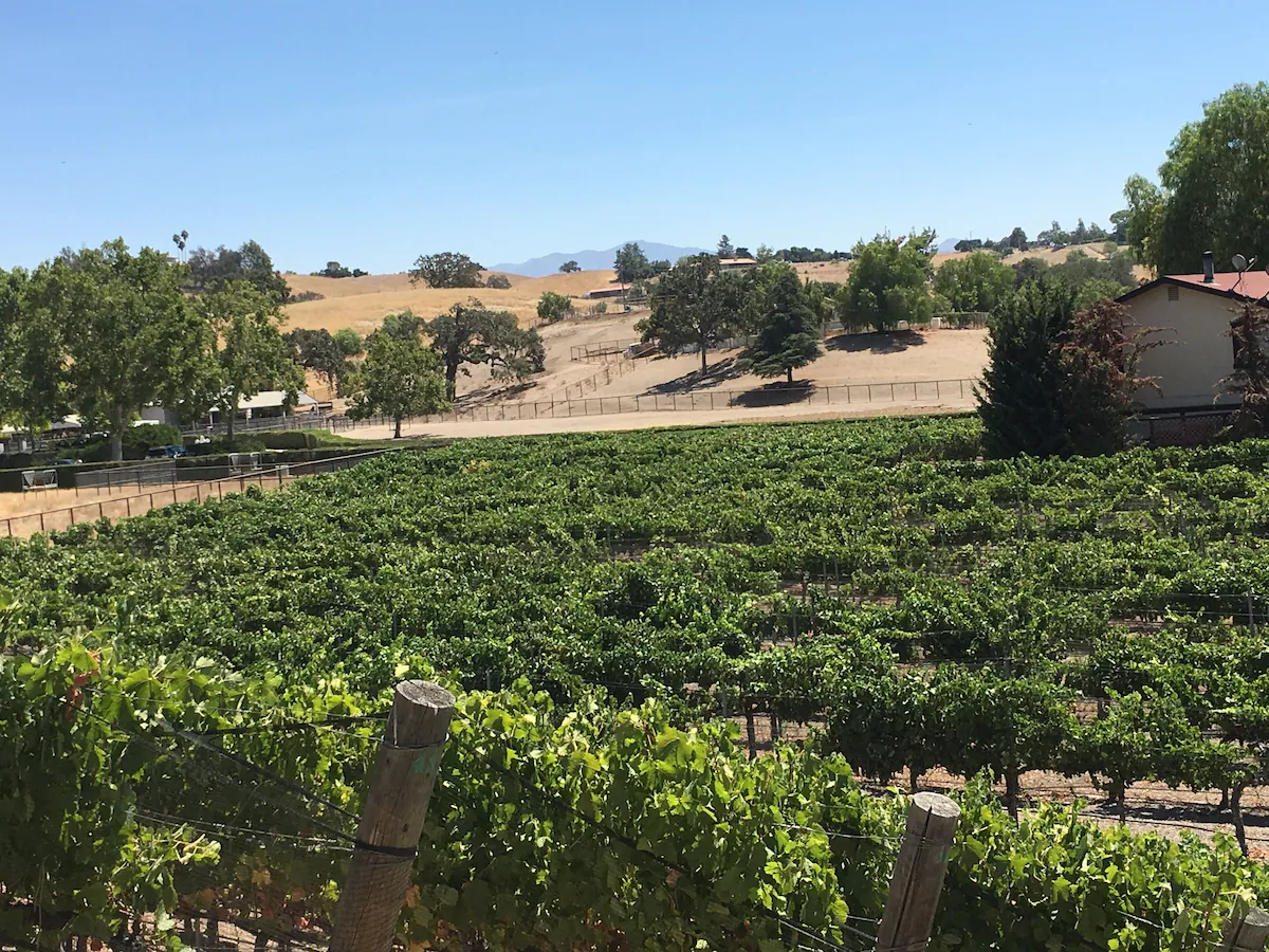
I recently visited Los Olivos, California for the first time for my cousin’s bachelorette weekend, and it was the epitome of cozy wine-country charm.
Tucked into the rolling hills of Santa Barbara County, this tiny town delivers big on wineries, walkable streets, and quaint, locally owned shops and businesses.
While I didn’t plan a single ounce of this trip (shout out to my cousins’ MOH), I still had a blast, and I would highly recommend Los Olivos for a girls’ getaway. Here was our complete weekend itinerary, packed with where to stay, what to bring, places to see, and things to do. May this guide serve as inspiration for planning your own Vino before the Veil celebration.
Weather in Los Olivos
Los Olivos offers mild, welcoming weather most months, but the feel of the trip can vary depending on the season.
Spring (March–May)
Expect comfortable days in the 60s and 70s, with wildflowers popping across the hills. Cool evenings make layers useful.
Summer (June–August)
Warm and sunny with highs from the 80s to low 90s, but still pleasant thanks to the valley breeze. Afternoons are perfect for shady patios or chilled rosé.
Fall (September–November)
Arguably the best time to visit. Harvest season brings golden vineyards, mid-70s temperatures, and crisp nights ideal for fire-pit hangouts.
Winter (December–February)
Cooler and cozier with highs in the 60s and chilly evenings in the 40s. A great season for warm sweaters and quiet tasting rooms.
Arrive by midday. Check-in isnt until 3 pm. Start the weekend by exploring town first. Depending on timing, it may be possible to grab a wine tasting reservation, or simply wander into a spot that looks inviting and enjoy a relaxed first glass of the weekend.
Once everyone settles into the rental, enjoy a home-cooked dinner, board games, crafts, face masks, and firepit/hot tub time!
Saturday:
Morning: The day begins with a hearty breakfast spread at the house, giving everyone a solid base before a full day of wine tasting.
Before 10:00 AM: While getting ready for the day, guests can choose a sandwich from Panino Grill, a local favorite known for its incredible sandwiches. The order can be placed ahead of time and picked up to bring along for the day’s adventure.
10:30 AM: A party bus picks everyone up at the rental and heads out toward the vineyards. We used: Nipomo Limo and Party Bus Rental
10:45 AM: The first stop is a wine tasting at Koehler Winery. Known for its beautiful outdoor setting and scenic vineyard views, it’s a relaxed place to enjoy a tasting, take photos, and even spot the small group of resident emus wandering the property. You’ll also find Willy the winery cat lounging around.
1:15 PM: The afternoon continues at Firestone Vineyard. This is a great spot to enjoy lunch from Panino and relax with bottles of wine or an additional tasting, either in the lounge or outside with sweeping views of the vineyards.
3:15 PM: Everyone loads back onto the party bus for the return trip to town.
3:30–5:00 PM: Spend time exploring Los Olivos. The town is filled with charming shops, tasting rooms, and even olive oil tastings. Since most places close or stop tastings around 4:00 PM, this is the perfect window to wander and discover a new favorite spot. We did olive oil tastings at Olive Hill Farm, and it was SO good.
5:00 PM: Walk back to the rental to relax, unwind, and get ready for dinner.
7:30 PM: Dinner at Trattoria Grappolo. Afterward, guests can head next door to the Maverick Saloon for a lively nightcap, or return to the house for a more laid-back evening.
Sunday:
Make a quick stop in nearby Solvang, a charming Danish-inspired village filled with pastries and shops. Enjoy a departure brunch and shop around a bit before hitting the road/
Cheers to good friends, good wine, and a weekend well spent in one of California’s most charming little wine towns.
If you’ve never taken a road trip through Arizona, it’s time to add it to the top of your travel list. This state is incredibly diverse, with red rock canyons, alpine lakes, quiet pine forests, desert valleys, and unique small towns . Arizona is one of those places where every direction offers something new, which makes it perfect for quick and easy weekend getaways.
It’s the sixth-largest state in the country and home to 22 national parks and monuments, two massive man-made lakes, and, of course, the Grand Canyon. Whether you love hiking, kayaking, scenic drives, or being surrounded by beautiful landscapes, Arizona has a way of delivering something memorable every time you visit.
I’ve road tripped through Arizona on several occasions, and even after exploring so many of its trails and landmarks, I still feel like there’s more to see.
If you’re planning your own Arizona road trip, these are the stops that should be on your itinerary.
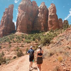
Sedona
Why stop here: Sedona is a must-stop for anyone who loves to hike. The area is filled with trails for all levels, from short walks with incredible views to challenging climbs up red rock formations. Hiking here is the best way to experience Sedona’s dramatic landscapes up close.
Top Hikes/Sceninc Views
Devil’s Bridge
Cathedral Rock
Boynton Canyon
Bell Rock
Birthing Cave
Capitol Butte
Fay Canyon
West Fork of Oak Creek Trail
Soldier Pass Trail
Antelope Canyon
Why stop here: One of the most photogenic slot canyons in the world Antelope Canyon is a must-see for photographers and anyone who appreciates unique natural formations. Guided tours are required to access the canyon.
Why stop here: Glen Canyon Dam overlooks dramatic red rock cliffs and is a great stop for photos and short walks. The surrounding area near Page also offers scenic viewpoints that make for a quick but memorable stop on your Arizona road trip.
Why stop here: This one might be a personal preference because I grew up going to this lake every summer, but it really is so beautiful on the water, especially at sunset. The Channel is the epitome of a partygoers’ scene, and the infamous London Bridge tends to be what people think of first, but I think of its crystal blue water and summers on the water.
Saguaro National Park
Why stop here: Iconic desert landscapes filled with giant cacti. Near Tucson, Saguaro National Park showcases the quintessential Arizona desert with endless trails and scenic drives.
Top things to do:
Drive the Cactus Forest Loop
Hike the Valley View Overlook Trail
Grand Canyon
Why stop here: One of the most famous natural wonders in the world The Grand Canyon is a road trip classic and deserves at least a few hours to explore.
Top things to do:
Hike part of the Rim Trail
Visit Mather Point for views
Desert View Drive to see multiple overlooks
Petrified Forest National Park
Why stop here: Ancient trees turned to stone, plus colorful badlands This park offers a mix of history, geology, and sweeping desert vistas. It’s a unique stop that’s very different from other parts of Arizona.
Top things to do:
Walk the Giant Logs Trail
Drive the 28-mile park road
Stop at Painted Desert viewpoints
The Wave
Why stop here: Located near the Utah border, The Wave is famous for its undulating sandstone formations. A permit is required, and extremely hard to get. I have never been here personally, but it is on my bucket list.
Why stop here: Havasupai Falls is one of Arizona’s most stunning hidden gems. It requires a permit, and you have to camp/backpack at least one night to be able to do it, or you can helicopter in and out. This is another one I haven’t personally done, but it’s currently top on my bucket list.
Why stop here: Iconic desert landscape with towering sandstone buttes Monument Valley is technically on the Arizona-Utah border and is a must-see for its sweeping desert views that have starred in countless movies. This is another stop I have not yet visited but is definitely on the list!
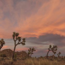
At first glance, 29 Palms feels like a remote military town in the middle of the desert. At a closer glance, it’s well, exactly that. But tucked between the Marine Corps base is also the North entrance to Joshua Tree National Park and a handful of surprising hidden gems. There’s a mix of unique restaurants, local art, and desert history that make this small town worth a stop.
Eat & Drink
29 Palms Brewery & Co. – Start your morning with artisanal coffee and breakfast, or swing back in the afternoon for craft beer. They have a wide selection of rotating lagers and ales made on-site, as well as a lunch and dinner menu.
Grnd Sqrl– A quirky café serving creative sandwiches, burgers, and comfort food, perfect for lunch after a morning of hiking. They also have an impressive beer list, featuring rotating draft and canned options. And, they have live music every Tuesday, Friday, and Saturday, and an open mic night on Mondays.
29 Palms Inn – A local landmark with fresh, seasonal dishes (many from their onsite garden) and a charming historic atmosphere beside the Oasis of Mara.
The Rib Co. – This little hole-in-the-wall stop is a must for barbecue lovers. They serve up slow-cooked ribs that fall right off the bone (my mouth is watering thinking about it) as well as other barbecue staples and hearty sides.
Stay
29 Palms Inn – The 29 Palms Inn has been welcoming guests to the desert since 1928, tucked away at the historic Oasis of Mara in Twentynine Palms. Spread across 70 acres with views of the Joshua Tree National Park mountains, this family-run spot (now five generations strong!) has a laid-back, eclectic vibe that makes it feel like no other place in the desert. It’s part history, part hideaway, and all-around the kind of retreat you’ll want to come back to.
Vacation Rentals & Airbnbs – From boho desert hideaways to family-friendly homes, there are a ton of options to choose from that are also in close proximity to the national park.
Camping – If you prefer to sleep under the stars, Joshua Tree National Park’s nearby campgrounds (like Indian Cove) are some of the most scenic in the desert. Also, there is the TwentyNine Palms RV Resort, only two miles from Joshua Tree National Park and the 29 Palms Marine Base, making it a perfect home base for RVers and travelers exploring the California desert.
Explore
Joshua Tree National Park – Enter through the 29 Palms (North) entrance for easier access and fewer crowds. Must-sees include Skull Rock, Arch Rock Trail, Cholla Cactus Garden, and Keys View.
Oasis of Mara – The historic Oasis of Mara has sustained life for more than 9,000 years, serving as a vital water source for Native Americans, settlers, and travelers, and inspiring the city’s name from the 29 palm trees once counted there. Today, its remaining springs and palms stretch from Joshua Tree National Park’s Headquarters to the 29 Palms Inn, where visitors can still experience this living piece of desert history.
Murals of 29 Palms – Take a stroll through downtown to see large-scale murals that celebrate the desert’s past and present.
29 Palms Art Gallery– Featuring work by local and regional artists, this gallery highlights the creative spirit of the hi-desert.
Not going to lie, the triple digits in the desert are pretty brutal. But, I’m always determined to still find things to do to make summertime fun and memorable.
Here is a list of everything I know of to do this Summer here in the Coachella Valley.
Grab a Sweet Treat
Nothing beats the heat like something sweet and refreshing! From creamy scoops to fruity blends, Palm Springs has no shortage of spots serving up frozen happiness. Whether you’re wandering downtown or just need a reason to leave the house, grabbing a cold treat is a summer must. Here is a list of favorites for locals and tourists alike.
Book yourself a little staycation, or locals’ tip, check out ResortPass and book a day at a resort pool! There’s a ton of options, and prices start at just $22.00.
Outdoor Adventures
While there is a bit of a shortage on outdoor adventure options during summer, here are a few great ones to still consider!
Palm Springs Aerial Tramway – One of the best summer escapes. Ride the rotating tram up to Mt. San Jacinto, where temperatures are often 30 degrees cooler. Enjoy walking trails, scenic views, and even a cocktail at the top.
Palm Springs Surf Club– The desert’s coolest new hangout. Whether you’re into wave riding or lazy river lounging, this reimagined waterpark is perfect for families, couples, or anyone looking to make a splash.
The Living Desert’s New Water Feature – In Palm Desert, this zoo and garden now offers a shaded, interactive splash area for kids — a fun (and educational!) way to stay cool while spotting giraffes, meerkats, and more.
Thursday Night VillageFest – When the sun goes down, head downtown. VillageFest transforms Palm Canyon Drive into a buzzing street fair with live music, local makers, and late-night eats. It’s a favorite summer tradition for locals and visitors alike.
Indoor Activities
Let’s be real, afternoons in Palm Springs are made for the indoors. Luckily, there’s no shortage of fun, air-conditioned ways to escape the heat while still making the most of your day.
Go Ice Skating at Berger Foundation Iceplex – Yes, you can ice skate in the desert! This cool escape in Palm Desert offers public skate sessions and rentals for all ages and skill levels.
See a Concert or Event at Acrisure Arena – From big-name artists to comedy shows and sporting events, this state-of-the-art arena is a must for summer nights.
Palm Springs Art Museum – A stunning mix of contemporary art, Native American work, and sculpture. Bonus: admission is free on Thursday nights from 5–8 PM.
Paint Your Own Pottery – Get creative (and stay cool) atOld Town Artisan Studio in La Quinta or Paint & Fire in Palm Desert — perfect for a relaxing solo outing or a fun date idea.
Agua Caliente Cultural Museum – Dive into the rich history and traditions of the Agua Caliente Band of Cahuilla Indians. A beautiful and meaningful cultural experience right in downtown Palm Springs.
Spa Day at the Spa at Séc-he – Treat yourself to ultimate relaxation at this luxurious new mineral spa. The architecture is stunning, and the amenities are top-tier.
Children’s Discovery Museum of the Desert – Recently reopened and full of interactive exhibits, this is a favorite for families with younger kids looking to learn and play indoors.
See a Magic Show at Marvyn’s Magic Theater – A fun, offbeat evening of comedy, illusion, and jaw-dropping sleight of hand. Perfect for a date night or something different with friends.
Shopping – Browse unique boutiques, vintage stores, and galleries along Palm Canyon Drive in downtown Palm Springs, or head to El Paseo in Palm Desert, known as the “Rodeo Drive of the Desert,” with luxury brands like Louis Vuitton, Tiffany & Co., and Saks Fifth Avenue. Both offer plenty of indoor air-conditioned shopping to help you beat the heat.
Eat & Drink
Visit Greater Palm Springs actually offers summer dining deals through their Summer Eats Pass. It’s an app you can download and check in to win weekly prizes! It’s from June 9 – September 1, 2025 this year.
I hope this blog helped spark some inspiration! I love summer and I am always trying to make the most of it. As always, travel on my friends!
Note: This post may contain affiliate links, meaning I get a commission if you decide to purchase something through the links, at no additional cost to you.
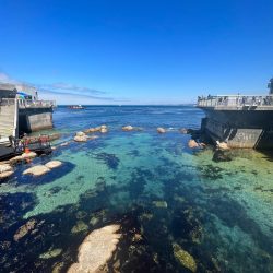
Monterey sure has changed alot since I lived there in college, but as a former local, here are my top recommendations!
Where to Stay
🌊 Monterey Beach Hotel – Mid-range: Stylish, beachfront hotel with direct ocean views (formerely Monterey Tides)
🏨 Spindrift Inn – Luxury: Romantic boutique hotel on Cannery Row with ocean views
Note: This post may contain affiliate links, meaning I get a commission if you decide to purchase something through the links, at no additional cost to you.
I want to yell from the rooftops and tell everyone I know to plan a visit to Mojave National Preserve, while at the same not tell a single soul so it remains a hidden gem because this road trip was that spectacular to me.
I first learned about some of these unique locations featured in this blog while I was working for a travel destination marketing company. Visit CA Deserts was one of our clients, and they’d just recently had a creator visit the area to capture content. I remember writing “Mojave National Preserve” down in my notes app as a reminder to research later. Fast forward a few years, I saw it sitting in my notes app randomly one day and shared it with my mom. Next thing I know, we were planning and executing a two-day road trip in the middle of nowhere! We’ve driven through the area many times before, and wow, I had no idea there were so many incredible hidden gems out in this seemingly barren desert.
So, if you’re looking for a unique desert adventure, look no further than the Mojave National Preserve located in Southern California! Here is a detailed 2-day road trip itinerary jam-packed with everything I’d recommend seeing and doing while visiting the Mojave National Preserve. Happy road-tripping!
Start from Palm Springs and head east on Highway 62.
Turn left on Godwin Road. Then, in 2 miles, turn right on Amboy Road.
Follow that down to Route 66 Highway and make a right.
Then, in 6.7 miles, you’ll make a left on Kelbaker Road towards the Providence Mountains.
In 11 miles, turn right onto Highway 40 and head east 21 miles until you reach Essex Road, then go North.
Stay left and follow Essex Road towards the Mitchell Caverns Visitors Center.
From Los Angeles
About 3.5 – 4 hours
Head east out of Los Angeles on I-10.
Take I-15 North. Follow signs for Barstow/Las Vegas.
Merge onto I-40 East. Continue on I-40 toward Needles.
Take Exit 100 for Essex Road. Turn left onto Essex Road.
Drive North on Essex Road. Continue for about 16 miles. You’ll see signs for Providence Mountains State Recreation Area.
Arrive at Mitchell Caverns Visitors Center.
From Las Vegas
About 1.5 – 2 hours
Start on I-15 South. Head south from Las Vegas towards Barstow.
Take Exit 184 for Nipton Road/CA-164. Turn left onto Nipton Road (CA-164) and head east.
Turn Right on Ivanpah Road. Follow Ivanpah Road south.
Turn Left onto Morning Star Mine Road. Continue through the Mojave National Preserve.
Turn Left onto Essex Road. Follow Essex Road for about 16 miles.
Arrive at Mitchell Caverns Visitors Center. The entrance will be within Providence Mountains State Recreation Area.
Search for a car rental
Day 1: Mitchell Caverns & Hole-in-the-Wall Rings Hike
Mitchell Caverns
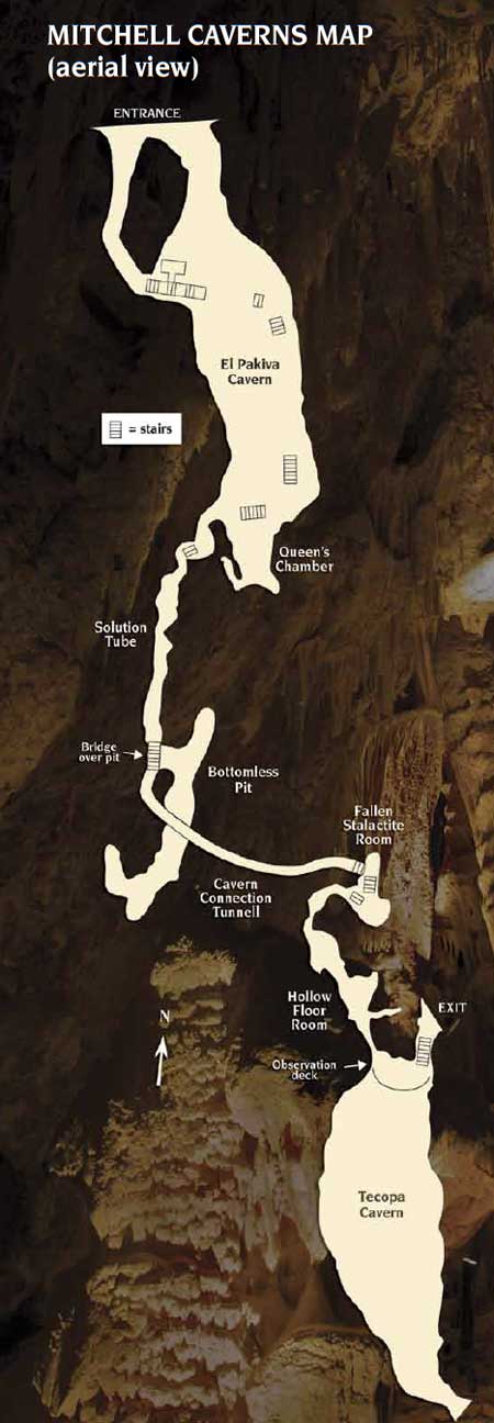
Our journey began with a road trip to the Mitchell Caverns. The Mitchell Caverns are located in the Providence Mountains State Recreation Area, at an elevation of about 4,300 ft. They reopened for public tours in November 2017. As the only limestone caves in the California State Parksystem, this tour is incredible and a must-do. Seriously, I can not recommend it enough; it was awesome. Our tour guide was exceptionally knowledgeable and quirky, and the pictures we captured inside the cave don’t do justice to what you’ll see with your eyes in person.
The caverns were originally known to the Chemehuevi people, the Indigenous inhabitants of the region, who viewed them with spiritual significance. Later, in the late 1800s, prospectors and miners stumbled upon the caves while searching for silver, gold, and other minerals in the desert. However, it wasn’t until Jack Mitchell arrived in 1934 that the caverns became known to the public. He recognized their potential as a tourist attraction and, along with his wife Ida, turned them into a roadside destination, leading guided tours.
Know Before You Go:
The Mitchell Caverns are only accessible by tour.
Tours are 2-hours long and must be made in advance here.
They are available October-May only at 11 a.m. and 2 p.m. on Fridays, Saturdays, and Sundays (and Holiday Mondays).
$20 per adult & $10 per child (16 and below)
Arrive 15 minutes before your scheduled tour.
The Mitchell Caverns Visitor Center is where you’ll check in and meet the ranger guide who will lead you through the caverns. It’s also a charming museum housed in one of the original stone buildings built by Jack Mitchell. The information desk is staffed by friendly, knowledgeable park employees who are happy to share their expertise about the area’s history and natural surroundings.
When you’re driving to the visitors center, you’ll first see a parking area at the bottom of a steep road with public restrooms and a campground. I would recommend stopping here first to use the restroom, and then driving up to the parking lot at the top, adjacent to the visitors center.
If you arrive early and have checked in already, there’s also a 0.5-mile, easy loop trail located near the visitors center with great scenic views of the surrounding Mojave Desert.
The Tour
The tour begins at the visitor center. A ranger will lead you along a ¾-mile hike to the cave through “sky island”, a unique higher-elevation area in the middle of the desert that has its own mini ecosystem. You’ll see plants like pinyon pines, juniper trees, and manzanita bushes that don’t grow in the lower, drier parts of the Mojave. And keep your eyes open, some of the bugs and critters that live up there can’t be found anywhere else in the world.
Along the way to the cave, you’ll also experience great views of the surrounding desert and learn about the area’s mining and biological history. Your tour guide will also go into way more fun details about Jack and Ida’s story.
The guided cave tour lasts about 2 hours, covering a total distance of 1.5 miles (including the trail to and from the cave), with stairs and occasional low and narrow passages.
A rare column, where stalactite meets stalagmite (Only 1 in 4,000 caves feature this!)
Your tour guide will explain these in way better detail than I could ever conjure up.
Temperatures inside remain a comfortable mid‑60s°F year-round. The thick layers of rock and soil above and around the cave shield it from the weather. So even if it’s blazing hot in the desert or freezing cold in winter, those temperature swings don’t reach deep into the cave.
Just look at those stalactites!!
I do remember that the stalactites are the icicle-shaped mineral formations that hang from the ceilings of caves because they “hang tight” from the ceiling, and stalagmites “grow with all their might” from the cave floors.
After you finish up your tour of Mitchell Caverns, I’d recommend heading back down to the picnic benches near the campgrounds and restrooms and enjoying a packed lunch and some snacks before heading back out on the road.
Hole-in-the-Wall Rings Hike
Getting There (from Mitchell Caverns)
Distance: About 35 miles
Drive time: Around 1 hour
Route: From the Mitchell Caverns turnoff, head south on Essex Road. Then, take a right on Black Canyon Road and follow it north for roughly 20 miles to the Hole-in-the-Wall Visitor’s Center.
Know Before You Go
Parking is FREE
The hike does require some arm strength as you have to pull yourself up on iron rings.
Best time to visit is between September–May; very hot in summer .
Cell service is very spotty so don’t count on reception to know where you are and where to go.
The Trail
Distance: 1.4 mile loop
Duration: About 1 hour
Elevation gain: Around 131 ft.
Difficulty: Rated Moderate
The trail starts right behind the Hole-in-the-Wall Visitor Center, where you’ll find trail signs pointing you toward the loop. The beginning of the hike is very flat and sandy; you’ll see yucca, creosote, and cactus.
As the trail wraps around, you’ll start to see the landscape close in. The sand gives way to rocky, narrow walls as you enter Banshee Canyon, where the real fun begins.
As the trail wraps around, you’ll start to see steep, rocky walls. This is known as Banshee Canyon. Hole-in-the-Wall gets its name because of those unique holes in the rock walls.
There’s two sections in the canyon that have steel ring bolts anchored into the rock. Hikers climb down (or up) using these rings.
It’s a fun and pretty easy family hike. It’s really only rated moderate because, again, it does require some arm strength to ascend up the rings.
After finishing up the hike, we headed out of the preserve and towards the hotel we were staying at for the night.. The closest option is just over an hour away in the small town of Primm.
Where to Stay
Buffalo Bill’s Resort & Casino (Primm, NV)
We stayed the night at Buffalo Bill’s Resort & Casino, located just off I‑15 in Primm. It’s the closest hotel to the Mojave Preserve. It’s not luxury-level, but it perfectly suits an overnight stay. For us, it was exactly what we needed: a clean room, easy access to gas, food, and a comfy bed after hiking.
A lot was under renovation when we went. The iconic buffalo-shaped pool has just reopened (I read as of May 2025), and The Desperado roller coaster is now undergoing regular maintenance checks, but is not open for rides yet. Other entertainment features like the log flume also haven’t reopened since the pandemic. But, for a place to lay your head in between two jam-packed days of exploring, it was just what we needed..
Primm Valley Resort & Casino (next door): A slightly more upscale sibling property, with similar amenities plus a golf course and spa. Worth considering for longer stays or if you seek a few extra perks.
Barstow area motels (102 miles away): Options like Best Western Desert Villa Inn and Super 8 offer budget-friendly stays, but at a much longer drive (1 hr 45 min).
Camping within the preserve: The preserve itself offers two developed campgrounds and group sites, great for stargazing.
Day 2: Teutonia Peak, Lava Tubes & Kelso Dunes
Teutonia Peak
Day two started with an early morning departure from Primm. We headed south back into the Mojave National Preserve. Teutonia Peak Trail is located near the northern edge of the Cima Dome. The drive to the trailhead takes just under an hour and winds through open desert landscapes and iconic Joshua trees.
The Trail
Distance: 4 miles, out & back
Duration: About 2 hours
Elevation gain: 700 ft.
Difficulty: Rated Moderate
The trail takes you along what was once the densest Joshua tree forest in the world. Although parts of the area were affected by the 2020 Dome Fire, you’ll still see a very dense population of these iconic trees.
As the trail climbs gradually, you’ll be treated to sweeping views of the Mojave Desert and surrounding mountains. The summit of Teutonia Peak provides a full panorama.
Lava Tubes
After hiking Teutonia Peak, we continued our Mojave adventure with a short detour to one of the preserve’s most photogenic spots: the Lava Tubes.
How to Get There
From the Teutonia Peak trailhead, head south on Cima Road for about 15 miles, then turn left onto Aiken Mine Road, a wide dirt road (high clearance is recommended, but in dry conditions, most vehicles can make it if driven carefully). Follow Aiken Mine Road for approximately 5 miles. Keep an eye out for a small sign on the left and a marked parking area. It’s easy to miss if you’re not paying attention.
The Walk to the Tubes
From the parking lot, it’s a quick 0.25-mile walk to the entrance of the Lava Tubes. After walking on the path for a few minutes, you’ll start to spot a metal staircase inside a large hole in the ground. That is where you’ll enter down into the cave.
Know Before You Go
Bring a headlamp. When you first climb through the cave, it’s pitch black, and your iPhone flashlight won’t help at all.
To see the iconic light beams that filter through the holes in the cave ceiling, aim to arrive between 11 AM and 1 PM, when the sun is at its highest.
Dust in the air helps highlight the beams. Gather some dirt in your hands and toss it in the air or gently kick up some dirt before snapping photos to get the iconic pictures you may have seen online. We visited at the right time, so we were able to catch the light beam, but I didn’t know about the dirt trick until after visiting unfortunately.
Kelso Dunes
And last but certainly not least, we made a quick stop at the Kelso Dunes before heading out. To be honest, we were pretty beat and ready to get on the road when we arrived here, so we did not hike in very far, but it was still cool to see..
The hike to the top is about 3 miles round-trip with 600 feet of elevation gain, and while the trail isn’t technically difficult, hiking through sand is a serious workout. There’s no official trail, just follow the footprints up the ridgeline. Most visitors aim to start around sunrise or late afternoon to avoid the heat and catch the dunes in their most photogenic light. It does also get prettier the further in you hike, or so we heard anyway.
What to Know Before You Go
Dogs are allowed, but the sand can get hot. It’s best to go early or late in the day if you’re bringing your pup.
There are no facilities at this trailhead.
And that officially marks the end of this awesome 2-day road trip! I hope you enjoyed following along on this Mojave Desert adventure as much as I loved putting it together. It was one of those trips that surprised us in the best way possible. I never realized just how many cool hidden gems were tucked away right in the middle of the desert.
If you made it this far, thanks so much for reading. As always, travel on, my friends!
Note: This post may contain affiliate links, meaning I get a commission if you decide to purchase something through the links, at no additional cost to you.
Tucked just north of Palm Springs, Desert Hot Springs is a hidden gem in Southern California, renowned for its naturally occurring mineral-rich waters. Unlike many hot springs that carry a strong sulfur scent, the waters here are odorless, crystal-clear, and geothermally heated—making them a rare and rejuvenating experience. With aquifers flowing beneath the desert surface, the town is home to dozens of boutique spas and resorts that tap directly into these healing waters, offering visitors a soothing escape rooted in nature’s own wellness remedies.
The History of Desert Hot Springs’ Mineral Waters
The history of the healing waters in Desert Hot Springs dates back to ancient traditions of the indigenous Cahuilla people who discovered and utilized these mineral-rich springs for their medicinal properties. These natural springs were believed to possess transformative powers, attracting people from far and wide seeking relief from ailments and spiritual rejuvenation. In the early 20th century, Pioneer Cabot Yerxa recognized the potential of these springs and built a homestead nearby, ultimately laying the foundation for the town’s reputation as a sanctuary for healing and relaxation.
The healing waters emerge from an intricate network of underground aquifers sourced from the nearby San Bernardino Mountains. Rainfall and snowmelt from the mountains filter deep into the earth, where they are naturally heated by geothermal activity. As the water journeys through layers of rock and sediment, it absorbs a rich array of minerals, including calcium, magnesium, and potassium. Eventually, this mineral-rich water finds its way to the surface through faults, forming the natural hot springs that have made Desert Hot Springs renowned for their healing properties.
The Health Benefits of Mineral Water
The mineral-rich waters of Desert Hot Springs are celebrated for their myriad health benefits, making them a popular destination for wellness seekers and spa enthusiasts. Here are just a few of the therapeutic properties attributed to these rejuvenating waters:
Relief from Aches and Pains: The mineral content of the water, particularly magnesium and calcium, is believed to help alleviate muscle tension, joint stiffness, and chronic pain conditions such as arthritis and fibromyalgia.
Skin Rejuvenation: Soaking in mineral water can nourish and hydrate the skin, promoting a healthy complexion and soothing skin conditions such as eczema and psoriasis. The silica content is especially prized for its skin-renewing properties.
Stress Reduction: Immerse yourself in the warm embrace of Desert Hot Springs’ mineral waters and feel your stress melt away. The tranquil surroundings combined with the therapeutic effects of the water create an ideal environment for relaxation and stress relief.
Improved Circulation: The heat of the water and the minerals it contains can help dilate blood vessels, improving circulation throughout the body. This can have positive effects on cardiovascular health and overall well-being.
Detoxification: The mineral waters of Desert Hot Springs are believed to aid in the body’s natural detoxification processes, helping to flush out toxins and impurities and leaving you feeling cleansed and revitalized.
Experiencing the Mineral Waters of Desert Hot Springs
Below is a list of properties you can stay at, with a few offering day passes. Find the best deals on where to stay in Desert Hot Springs at Trivago.com, using this link.
Desert Hot Springs Spa Hotel: This historic hotel offers a range of mineral water pools, including an Olympic-sized pool, hot mineral pools, and private tubs. Prices starting at $179/night
Two Bunch Palms: One of the oldest hot springs resorts in the area, and one of the most well-known, Two Bunch Palms features natural mineral water pools surrounded by lush gardens and tranquil desert scenery. Prices starting at $475/night
Miracle Springs Resort & Spa: With eight natural mineral pools ranging in temperature from 90°F to 104°F, Miracle Springs Resort & Spa offers a relaxing retreat for guests seeking rejuvenation and renewal. Prices starting at $169/night
Aqua Soleil Hotel & Mineral Water Spa: This property offers guests access to two mineral water pools and a variety of spa treatments designed to promote relaxation and well-being. Massage and spa services are available at the on-site spa. Prices starting at $112/night
Photo Credit: Booking.com
Sagewater Spa: Located in a serene desert setting, Sagewater Spa offers guests a peaceful retreat with private outdoor soaking tubs filled with natural mineral water sourced from the property’s own well. Prices starting at $299/night
Miracle Manor Boutique Hotel & Spa: Nestled in the foothills of Desert Hot Springs, Miracle Manor offers guests intimate accommodations and access to private mineral water tubs with breathtaking views of the surrounding desert landscape. Prices starting at $259/night
Azure Palm Hot Springs: This adults-only boutique hotel features natural mineral water pools and hot tubs, as well as cozy accommodations designed for relaxation and rejuvenation. Prices starting at $229/night
Hope Springs Resort: Tucked away in a quiet residential neighborhood, Hope Springs Resort offers guests a tranquil setting for soaking in natural mineral water pools and enjoying personalized spa treatments. There are 10 rooms and 3 pools and guest must stay a minimum of 2 nights. Prices starting at $520 for 2 Nights
El Morocco Inn & Spa: Inspired by the exotic beauty of Morocco, this charming inn features luxurious accommodations, lush gardens, and a relaxing spa offering a variety of therapeutic treatments and mineral water soaking experiences. Guests must stay a minimum of 3 nights. Prices starting at $220/night
The Good House: This intimate boutique hotel features beautifully appointed rooms and private outdoor mineral water soaking tubs, allowing guests to unwind and rejuvenate in a peaceful desert setting. Prices starting at $356/night
Tuscan Springs Hotel & Spa:Staying at Tuscan Springs Hotel & Spa offers a serene escape amidst Mediterranean-inspired gardens and luxurious accommodations. Guests can rejuvenate with access to healing mineral waters and spa treatments, promising a tranquil retreat in Desert Hot Springs. Prices starting at $269/night
MI KASA HOT SPRINGS: Mi Kasa Hot Springs provides a cozy oasis with rustic charm and soothing hot spring pools. Guests can unwind in the therapeutic mineral waters while enjoying the stunning desert vistas, offering a unique and rejuvenating experience Prices starting at $319/night
Desert Hot Springs Spa Hotel:This property offers a relaxing getaway with its array of mineral-rich hot springs and comfortable accommodations. Guests can indulge in therapeutic soaks and pampering spa treatments amidst the picturesque desert landscape, ensuring a rejuvenating stay. Prices starting at $279/night
Photo Credit: Desert Hot Springs Spa Hotel
The Onsen Hotel and Spa:Guests are invited to experience a serene retreat, boasting traditional Japanese-inspired design and tranquil hot spring baths. With a focus on relaxation and wellness, visitors can immerse themselves in the therapeutic waters while enjoying luxurious amenities and scenic views Prices starting at $239/night
Whether you seek relief from ailments or simply crave a relaxing getaway, Desert Hot Springs promises an unforgettable escape. Soak away your cares, immerse yourself in the healing embrace of these natural springs, and embark on a journey of wellness and renewal.
Murray Canyon Trail to Seven Sisters Waterfall is one of the most scenic and rewarding hikes in Palm Springs, California. This moderate hiking trail takes you through the Indian Canyons to a small hidden water fall payoff.
3.7 miles | Elevation gain 538 ft | Out & back | Rated Moderate
Indian Canyons is one of Palm Springs’ most breathtaking natural attractions, offering a rare blend of lush palm oases, flowing streams, rugged desert landscapes, and rich Native American history. Located on the ancestral land of the Agua Caliente Band of Cahuilla Indians, this protected area is home to some of the most scenic hiking trails in Southern California, including Palm Canyon, Andreas Canyon, and Murray Canyon.
The Trail:
The trail begins at the Indian Canyons Trading Post. Follow the signs guiding you towards Maynard Mine and Murray Canyon. Proceed south, crossing the dirt road over Andreas Canyon Creek. Once you’ve crossed, veer left immediately to stay on course toward Maynard Mine/Murray Canyon. Your journey unfolds along a road that winds through several picnic areas, shaded by beautiful arching palms. As you continue, you’ll eventually reach another trail sign and a map, marking the official trailhead for Murray and Maynard.
The path initially takes you through a desert landscape, along a dirt trail with not much shade but beautiful views of the surrounding mountains. Eventually the trail leads you down into Murray Canyon, guiding you along a creek through a lush palm oasis.
At the 1.5-mile mark, a connecting trail veers off to the left, leading upward towards the Coffman Trail on the ridge to the east. Keep right and continue on towards the Seven Sisters Waterfall. The next stretch is a bit more steep and rocky.
By the time you reach 1.9 miles, you’ll reach a final turn in the canyon towards the south, revealing the hidden gem—Seven Sisters Falls. It’s a small, tucked away flowing waterfall offering a moment of serenity; the perfect reward for conquering the journey.
Entry Fee: Be aware of the entry fees associated with your visit. Admission fees are as follows: Adults $12, Seniors 62+ $7, Students (with student ID) $7, Children (6-12) $6, Military (with U.S. military ID) Free, and Equestrian $11.
Respect Cultural Sites: The Indian Canyons hold cultural significance for the Cahuilla people. Respect the sacred sites, artifacts, and any cultural markers you encounter. Avoid touching or disturbing these elements.
Respect Wildlife: Indian Canyons is home to diverse wildlife. Observe animals from a distance, avoid feeding them, and respect their natural habitats.
Stay on Designated Trails: Stick to designated trails to protect the delicate desert ecosystem. Straying off the path can disturb plant life and contribute to erosion.
Check Trail & Weather Conditions: Before your visit, check the current trail conditions, as they can vary based on weather and maintenance. Stay informed about any closures or restrictions to ensure a smooth and safe experience. Also, be mindful that the summer months in Palm Springs are very hot and frequently in the triple digits. I would recommend doing this hike anytime from the fall through the spring.
So, there you have it—Murray Canyon to Seven Sisters Waterfall! Happy Hiking!
From lush oases to challenging peaks, here are the best hikes near Palm Springs!
Contents
Note: This post may contain affiliate links, meaning I get a commission if you decide to purchase something through the links, at no additional cost to you.
Whether you’re a seasoned hiker seeking a challenge or a casual adventurer looking to connect with nature, Palm Springs has a hike to suit your preferences. The surrounding mountains and canyons provide a plethora of hiking opportunities for outdoor enthusiasts of all skill levels. As a desert native and a hiking enthusiast, these are actually my top ten best hikes spanning across the entire Coachella Valley, not just in the city of Palm Springs. But, most people who aren’t from the desert, don’t recognize the name Coachella Valley, they are only familiar with where Palm Springs is so I decided to name the blog as such. Anyway, happy hiking!
There’s a small parking lot by Rim Road adjacent to a mobile home park. Please note that the trailhead isn’t actually in the mobile home park even though maps often make it look like it is. You will however, hike alongside it at the very beginning.
Araby Trail is definitely one of the most favored trails in the city of Palm Springs. Hikers are treated to breathtaking views of the surrounding mountains and a unique glimpse of the Bob Hope House, an architectural marvel. The trail is pretty much all uphill, covering a fair amount of elevation gain in just 1.7 miles, so be prepared, I definitely wouldn’t consider it an easy climb.
Tahquitz Canyon offers a perfect outing for families seeking a quick adventure. This easy to moderate hike takes you along ancient rock formations to a 60-foot waterfall payoff. Although it’s family-friendly, furry companions must stay home. Keep in mind the $15 per person fee ($7 for children aged 6-12) as it’s considered sacred land, owned by the Cahuilla Indians. An annual pass is available for $125. You also have to be 18 or older to enter the canyons alone. The park operates from Oct. 1 to July 4 from 7:30 a.m. to 5 p.m. daily (with the last hiker allowed on the trail at 3:30 p.m.).
Murray Canyon is located in the Indian Canyons between Palm Canyon and Andreas Canyon in the city of Palm Springs. The starting point of the trail is located at the same developed trailhead used for accessing Andreas Canyon. You may however, drive a short distance further into the picnic areas, which will trim a little less than 0.4 miles off the roundtrip distance. Please note that Indian Canyons does require an access fee, as it’s also considered sacred land, owned by the Cahuilla Indians. General admission for adults is $12.
This hike guides you along an easy desert terrain, offering views of sweeping vistas before leading you into the canyon where you’ll hike alongside a stream. The trail does cross over the stream multiple times, but for the most part, you shouldn’t get wet as there are rocks and logs guiding you over the water. I do recommend sturdy hiking boots or water shoes if you’re concerned about getting wet though. In the canyon, you’re also surrounded by lush vegetation and unique flora & fauna. The waterfall at the end of the trail is a wonderful payoff. Unlike the Tahquitz Canyon, 60-foot waterfall, Seven Sisters is much smaller and a bit tucked away, but still beautiful and refreshing.
The full Art Smith trail is a total of 16.2 miles and is considered challenging. But, if you’re looking to experience the beauty of this hike without committing to the full 16.2, consider doing Art Smith to the first oasis. It’s about 6 miles round trip, covering approximately 1,200 ft. total of elevation gain, leading to a small palm oases (shown below in the last image). The trailhead can be found off Highway 74, about 1/4 mile past the Bighorn Country Club. The best times to visit this trail are September through May. You’ll need to leave pups at home — dogs aren’t allowed on this trail.
Park at the unpaved lot located at the intersection of Avenida Bermudas and Calle Tecate. Follow the Cove Oasis Trail for 0.67 miles before turning left (you’ll see a Cove to Lake Trail sign). The first section of the trail is very flat but be prepared to walk aways in sand. As the trail progresses, expect moderate elevation changes. Hikers will experience stunning views of the Santa Rosa mountains and the nearby Quarry Golf Course. Eventually, the trail leads you to Lake Cahuilla, a small reservoir open for recreational fishing and camping.
Located at the eastern end of Avenue 42nd and the northern end of Golf Center Parkway in the city of Indio, the East Indio Badlands Trail offers a 5.2-mile loop showcasing a diverse array of geological formations, desert vegetation, and panoramic vistas of the Coachella Valley. The hike begins along the edge of the Terra Lago Resort Golf Course and leads you into a slot like canyon. Once out of the slots, you’ll experience a small accent with a nice payoff overlooking the entire desert. This trail is also very dog-friendly!
Begin your journey by driving to the Palm Springs Aerial Tram. Purchase your tram ticket and prepare for an exhilarating ride to the summit! The tram itself is a great experience, boasting the World’s Largest Rotating Tramcar. The Palm Springs Aerial Tramway travels over 2.5 miles up to the Mountain Station at 8,516 ft in just 10 minutes. The temperature at the Mountain Station is also 30 to 40 degrees cooler than the valley floor.
Once you make it up to the top of the tram, your next journey begins. The hike to San Jacinto Peak is 10.1 miles, out & back, covering 2,578 ft. of elevation gain. It’s no easy feat. The best times to visit this trail are March through November but check the weather conditions because depending on the winter, March may still be very snowy, with late storms blowing in. Also be sure to acquire a permit. Day-use permits can be obtained on the day of your trip by visiting the ranger station, which can’t be missed because you must past the ranger station to continue on the correct trail route.
The Bump-n-Grind Trail in Palm Desert is arguably the most popular hiking trail in the desert for locals looking for a good workout. The hike is known for its challenging incline and breathtaking views of the Coachella Valley. It’s a 4-mile loop that gains about 1,000 feet in elevation, making it a quick but intense workout (usually around 1 hour, depending on your fitness level).
This an easy 1.8 mile, out & back trail that’s great for kids and family! This trail features numbered stops providing insight into the surrounding fan palms, the San Andreas Fault, desert pupfish, and other geological and ecological wonders of the preserve.
For those looking for more information on the Coachella Valley preserve or other hiking trails to explore there, check out my blog, Exploring the Coachella Valley Preserve.
The Palm Desert Cross has definitely become a local landmark and one of the most popular hikes. It’s a fairly easy accent and it is dog-friendly. You can either do it as an out& back journey, turning it into about a 2.2 mile hike, or you can do the loop, extending it about an extra mile. The loop also takes you down to another hidden gem, the Yin Yang mural.
Honorable Mentions
Mission Creek Preserve – Desert Hot Springs
South & North Lykken Trail
Randall Henderson Loop – Palm Desert
Favorite areas just outside of the Coachella Valley
Whitewater Preserve
Ladder Canyon/Painted Canyon
Joshua Tree National Park
Morongo Valley Preserve
Whether you’re an avid hiker looking to conquer Cactus-to-Clouds or just looking to get out in nature at the Coachella Valley Preserve, I hope this round-up has helped you navigate your next adventure. Happy hiking my friends!
Cactus-to-Clouds is a 21-mile assent from the Palm Springs valley floor, starting at about 400 feet, up to the San Jacinto Peak at 10,834 feet. It is rated one of the hardest day hikes in the United States, and the trail actually has the largest elevation gain out of any hike in the United States. Skyline trail takes you up about 9.4 miles, starting behind the Palm Springs Art Museum and ascending to the top of the Palm Springs Aerial Tramway. Then, to do the full Cactus-to-Clouds hike, you continue for another 11 miles to the peak and back down to the tramway station to ride the tramcar back down to the valley floor.
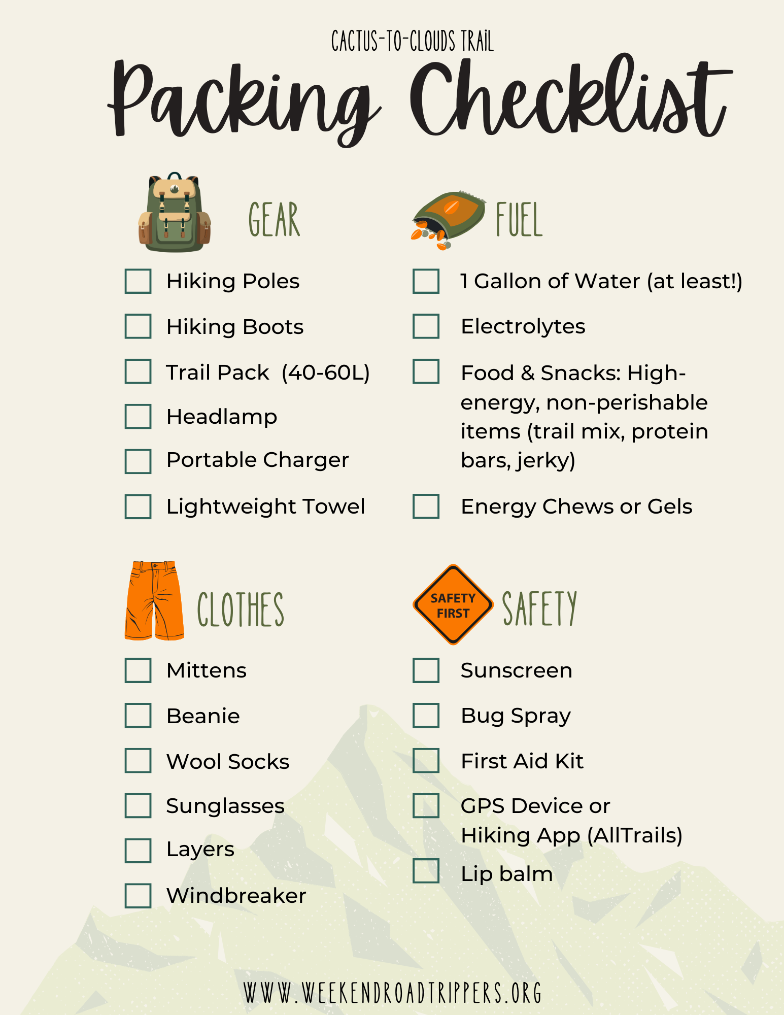
WHAT TO PACK
Here is a list of everything I packed, with links to a few recommended essential items. I don’t gain any commission on any of these items, this is just exactly what I packed and what I would recommend (as a female hiker).
Layers, Layers, Layers – I wore biker shorts and a long sleeve dri-fit with a hat, which was perfect for the heat during the first half of the trek, and then I packed, sweatpants, a hoodie, a light windbreaker, and a larger warm jacket, a beanie, and mittens. By the time I reached the peak, I had every layer on and was so glad I packed it all.
Hiking Boots – I always recommend boots with ankle support for long hikes.
AT LEAST 1 Gallon of water – I brought three, 1.5 liter SmartWaters. Not the most environmentally friendly I know, but it was the most comfortable and cheap way I could think to pack them all on my back. I also packed four additional 16.9-ounce plastic water bottles that I had pre-prepared with the electrolyte and magnesium tablets ahead of time. I know most hikers use a bladder as well, which is also an option (I, for some reason, am not a huge fan). I packed all of this and still filled up two more of my SmartWaters at the Ranger Station at the top of the tram and completely drank both of those too by the end of the hike.
Snacks! – I cut up two protein bars into small bite-size pieces and put them in a baggie to snack on throughout the day. I’d also recommend some sort of salty snack like trail mix, crackers, etc. I also packed a peanut butter and honey sandwich, which is always my go-to trail food. It is recommended to try and eat something small every hour!
Hiking Backpack– Make sure it’s large enough to fit everything mentioned above (At least 35L)
Aside from what to pack, here’s a few other useful tips/information to consider.
Start at the Right Time – It is recommended you start this hike between 12 a.m. and 4:30 a.m. to allow yourself enough time to finish before the last tram car down at 9:30 p.m.
Hike During the Right Time of the Year – Fall is really the best season to do this hike so that the temperature isn’t too hot at the beginning and isn’t too cold as you reach the top. Temperatures in Palm Springs are in the triple digits during summer and temperates at the top of the Palm Springs Aerial Tramway are typically around 30 degrees in the winter with plenty of snow.
Pack AT LEAST 1 Gallon of Water – There are two rescue boxes along the trail that sometimes contain extra water left behind by other hikers, and you can also fill up at the ranger station at the top of the tramway, but I would definitely not rely on these sources, but they are good to know about beforehand in case of emergency. You will be hiking for many hours and need to be properly hydrated the day before the hike AND during the hike. Also, on that note, carb load the night before. I recommend a pasta night.
You Will Need a Permit – You must obtain a permit before continuing on once you reach the top of the tram. The permits are free and located at the ranger station. This not only allows rangers to protect the wilderness but is also meant to keep you safe. With limited cell service in the San Jacinto mountains, permits allow the rangers to know if you’ve safely returned from your hike.
Know Where to Park at the Trailhead – 101 N Museum Dr, Palm Springs, CA, 92262, USA. Do not park in the museum parking lot or the parking garage across the street or you will be ticketed (or worse, towed). There is however, free street parking around the museum with plenty of spots if you start early morning. Also keep in mind, you will be finishing the hike at the parking lot at the bottom of the Palm Springs Aerial Tramway, which is actually around 20 minutes from where you began your journey behind the Palm Springs Art Museum. Be sure to have a plan for how you will get back to your car.
THE ROUTE
Lastly, here are some trail markers that are helpful to know so you can see how far you’ve traveled and how many miles you still have left to go!
I hope this blog helps anyone out there looking to cross this beast of a hike off their bucket list. Happy hiking!


