Looking to take a drive through Joshua Tree National Park? Here are my must-stop locations that don’t involve much hiking. The park has three different entrances so be sure to do your research on where each of these stops are located so that you can map out the best route.
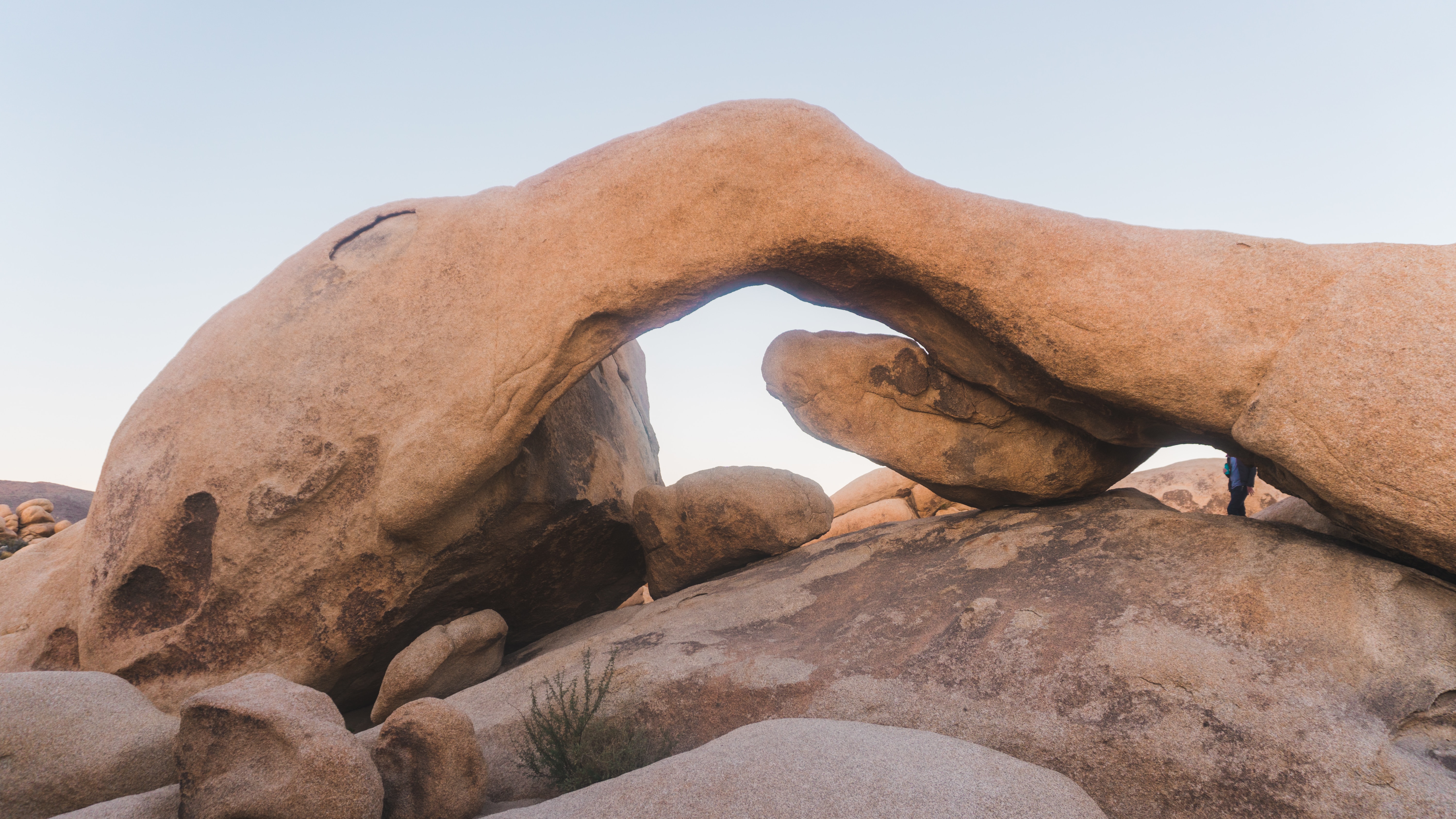
Arch Rock
You can reach this iconic site by embarking on a moderate half-mile hike. The trail offers picturesque views of hundreds of Joshua Trees, diverse flora and large rock formations leading to the awe-inspiring rock formation characterized by a natural arch.
Heart Rock
Located in the same area as Arch Rock, Heart Rock can be found with just a half mile walk from where you park your car. The trail will lead you do a sign with one direction pointing towards Arch Rock and the opposite direction pointing towards Heart Rock.
Cholla Cactus Garden
Cholla Cactus Garden is located in the park’s Pinto Basin and showcases a dense congregation of cholla cacti. You can explore the garden via a short quarter-mile walk.
Keys View
At an elevation of 5,185 feet, Keys View in Joshua Tree National Park offers a breathtaking panoramic vista of the surrounding Coachella Valley. Accessible by a short drive from the park’s entrance, this iconic viewpoint provides visitors with a spectacular overlook of the desert landscape, including the Salton Sea, San Andreas Fault, and the distant peaks of San Jacinto and San Gorgonio.
Skull Rock
Skull Rock is a unique rock formation that resembles a skull. The rock’s distinctive shape was carved by wind and erosion.
Jumbo Rocks
Jumbo Rocks is an area with massive granite boulders. The towering rock formations create a playground for climbers, while hikers can venture through the maze-like formations, and campers can witness stunning sunsets and star-filled night skies.
Barker Dam
Barker Dam is a historical and scenic site that offers a glimpse into the region’s past. This small reservoir was constructed by early cattle ranchers and homesteaders in the late 19th century. Today, visitors can embark on a short hike to reach the dam and explore its surroundings.
Wall Street Mill
Wall Street Mill is also a fascinating historical site.. Accessible via a moderately easy hike, this well-preserved mill stands as a testament to the region’s gold mining era in the early 20th century.
Hidden Valley
Hidden Valley is a picturesque and secluded area within Joshua Tree National Park. Tucked away from the main road, Hidden Valley is accessible via a short walk from the parking area. This enclosed area is surrounded by towering rock formations, creating a natural amphitheater. Hidden Valley is also a popular spot for rock climbing and bouldering
I hope this blog provided some insight on quick stops for an afternoon exploring Joshua Tree National Park. As always, travel on my friends.
Last weekend my parents and I spent the day in Joshua Tree and here’s what we did.
We met at Joshua Tree Coffee Company at 10 a.m. because every trip to Joshua Tree National Park must begin with a cold brew from JTree Coffee Co. It was packed there that morning (maybe due to Coachella Fest) and my cold brew took quite a while to make. I didn’t have much of a breakfast that morning and noticed a pop-up shop next to the coffee shop serving fresh quiches and wow, best decision. I wish I knew the name of the little place next door but I will say, if they’re always there, go. Run!
My cold brew was fantastic too, of course.
We then drove into the park via the West Entrance, which is about 10 miles east from the city of Yucca Valley. We were there on a Saturday and thought it was going to take a while to get in but the wait was quick. I also bought a new National Park Pass, which I renew every year. If you’re a frequent hiker/traveler, I would highly recommend getting the pass! It’s $80 and most day passes into parks are $30-$40. We live close to Joshua Tree National Park and usually plan a trip to at least one other park each year, making the pass so worth it. It also gets you access to a lot of other state parks and landmarks!
Once inside the Park we headed toward Ryan Mountain, which is located in the central part of the park. We actually had never hiked this trail before and it was tougher and steeper than we thought it was going to be. Ryan Mountain is definitely one of the most rewarding hikes within Joshua Tree National Park though, offering stunning views of the desert landscape from its summit. The trail, which is 3 miles round trip, is clearly marked and easy to follow. It has a total elevation gain of 1,050 feet and the elevation at the top is 5,457 feet. Although the ascent is steep in parts, hikers of all levels can complete the journey. Once at the top, you can take in the awe-inspiring panoramic views of the surrounding desert. We were shocked at how green the landscape looked due to the amount of rain we had this spring. We could also clearly see three snowcapped mountains in the distance: San Jacinto, Big Bear and what we think was San Gorgonio.
After hiking Ryan Mountain, we planned to stop and see two more landmarks within the park (Arch Rock & Heart Rock), which I thought I remembered being in locations where you just park your car, get out and see them…but, I was a bit off unfortunately. We were quite tired from our hike and it was a very sunny day and Arch Rock/Heart Rock ended up being another 1.4 miles out & back. It was an easy route that took another 30 minutes to complete. It sure was pretty though! My parents had never been to Arch Rock and we all hadn’t seen the Heart Rock before.
We ended the afternoon with a celebratory, post hike beer on the patio at Joshua Tree Saloon. We were surprised with beautiful weather and fun live music and delicious iced cold beer.
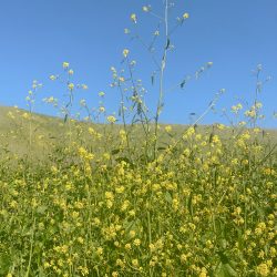
With the unusual amount of rain California has had this winter, nature lovers are expected to see the first Superbloom since 2019. In 2019, Jordan and I were able to hike in Walker Canyon and see the flourish of California poppies coating the hills. It was incredible. I was so sad to learn they closed the trail this year due to the traffic it created and the damage visitor’s caused by trampling the flowers for Instagram worthy pictures. With that closure, I’ve been doing my research, looking up other trails that are supposed to be vibrantly blooming this year and this is sort of just a bucket list blog of places I want to explore this spring rather than an experts guide on where to go and what to see this spring. Let me know if you stopped by any of these locations yet or have any other suggestions!
Indian Canyons – Palm Springs
While I have been here many, many times, I’ve heard the wildflowers are popping right now! Located just a few miles south of downtown Palm Springs, the Indian Canyons are home to a variety of wildflowers that bloom from March to May. There are three canyons within Indian Canyons worth exploring; Murray Canyon, Palm Canyon and Andreas Canyon. Each canyon offers several hiking trails where you can see a wide range of desert wildflowers, including lupine, poppies, and desert marigolds! You can also take a guided tour with a knowledgeable guide who can point out the different species and share interesting facts about the area’s flora and fauna.
Joshua Tree National Park is only a short drive from Palm Springs (and about 20 minutes from where I live) and is one of the best places to see wildflowers in the region! The park’s high desert landscape is home to a variety of wildflowers that bloom from February to April, including desert dandelions, Mojave asters, and desert primrose. I keep seeing pictures of the trails starting to bloom and beautiful Joshua Trees lining a soft green landscape and I’d love to hike out there sometime soon!
Located about an hour’s drive southeast of Palm Springs, Anza-Borrego Desert State Park is one of the largest state parks in California and is home to a stunning array of wildflowers. I was actually just here back in January and it was stunning but we did miss the wildflowers. The park’s vast desert landscape is home to a wide range of wildflowers that bloom from February to April, including desert sunflowers, sand verbena, and lupine.
Located about 30 minutes west of Palm Springs, the Big Morongo Canyon Preserve is a protected area of desert habitat that’s home to a variety of wildflowers. The preserve offers several hiking trails that take you through lush canyons and along the streams, where you can see wildflowers such as California poppies, desert marigolds, and lupine. The Morongo Preserve is actually walking distance from where I live in the city of Morongo, near Yucca Valley and Joshua Tree. I actually haven’t made my way over there in quite a while and want to head over soon to see if spring is in full bloom!
Located about 20 minutes north of Palm Springs, the Whitewater Preserve is a protected area of desert habitat that’s home to a variety of wildflowers. The preserve offers several hiking trails that take you through the lush riparian area and up to the rugged canyons, where you can see wildflowers such as desert dandelion, lupine, and sand verbena. The White Water Preserve is one of my absolute favorite places to hike, especially during spring. There’s a trail, “White Water Ranger Station to Cottonwood TH via the PCT” that allows dogs and is a vibrant green every spring so I can only image what the trail is looking like this year.I can’t wait to go!
Located about 20 minutes northwest of Palm Springs in the city of Desert Hot Springs, the Mission Creek Preserve is a protected area of desert habitat that’s home to a variety of wildflowers. The preserve offers several hiking trails that take you through the rugged canyons and up to the high ridges, where you can see wildflowers such as Indian paintbrush, chia, and desert dandelions. This is another area I love to visit because it’s dog friendly and my pups love to play in the fresh water. Last year the hills were a vibrant bright yellow so again, I can only image what they’re looking like this year. I can’t wait to take the pups over there soon.
This one isn’t really a hiking area but I keep driving by the windmills off the Interstate 10 on my way to work down in La Quinta and really want to stop one day and snag a few pictures. I read that visitors can see a variety of wildflowers here, including desert sunflowers, sand verbena, and purple mat, which you can see displayed in the carousel post from Greater Palm Springs below!
Located about 30 miles southeast of Los Angeles, Chino Hills State Park is a beautiful park that’s home to a variety of wildflowers. The park’s rolling hills and canyons are covered in wildflowers in the spring, including California poppies, lupines, and Indian paintbrush. Visitors can see the flowers on the park’s many hiking trails, which offer stunning views of the surrounding landscape. When I look up wildflower locations this spring, Chino Hills State Park keeps popping up as a top location. It’s only about an hour and 15 minutes for me so I’m hoping I can cross this one off my list this year.
Located in eastern California near the Nevada border, Death Valley National Park is a surprising place to see wildflowers in the spring. The park’s lower elevations receive less rainfall than other parts of Southern California, but when conditions are right, wildflowers will bloom vibrantly across the entire desert floor. I am so excited for this one. My family actually has had a trip planned for early May for a while now before even knowing how much rain we’d be getting this winter. It sounds like we will be visiting during the perfect time and the perfect year to see the the wildflowers in full bloom.
Located about 75 miles north of Los Angeles, the Antelope Valley California Poppy Reserve is a must-visit destination for wildflower enthusiasts. The reserve is home to the largest remaining stand of California poppies in the state, and the bright orange flowers typically bloom from late February to May. The reserve also offers several hiking trails and picnic areas for visitors. I probably won’t make it out this location since it’s over 3 hours away from me but man, I sure want to. It looks like THE place to see poppies.
Located in eastern San Luis Obispo County, the Carrizo Plain National Monument is a remote and rugged area that’s home to a wide variety of wildflowers in the spring. Visitors can see a carpet of California poppies, lupines, and other flowers covering the hills and valleys of the plain. The area also offers stunning views of the surrounding mountains and the Temblor Range. This is another location I probably won’t get to check off my list, but wow it looks stunning!
Located along the coast in western Ventura County, Point Mugu State Park is a great place to see wildflowers in the spring. The park is home to a variety of coastal wildflowers, including California poppies, lupines, and sea figs. Visitors can see the wildflowers on the many hiking trails that wind through the park, offering stunning views of the Pacific Ocean and the surrounding coastline. This is another location that is over 3 hours away for me but the pictures of the poppies with an ocean view, ugh, I would love to explore here.
And that completes my list of places I want to explore to see the wildflowers this year! What locations did I miss and have you had the chance to stop by any of these destinations yet?
While I am a summer girl through and through, I do love spring so very much. April is my birth month, and I love when when nature begins to bloom it starts getting warm enough to hit the trails again. May you all have a wonderful and “vibrant” spring this year!
I grew up in the Coachella Valley and have never been to Anza-Borrego, nor did I know so many incredible things were out there. We came across a few social media posts showcasing epic adventures and decided to start researching and planning a day trip. Here’s a guide to all we managed to pack into one fun-filled day!
Location
Anza-Borrego is located in Southern California, east of San Diego, south of Palm Springs, and west of the Salton Sea. If you’re familiar with off-roading, it’s just minutes away from Ocotillo Wells.
Weather
Summers are very hot and dry with temperates often in the triple digits. Fall and spring temperates usually range from the mid-70’s to low-90’s and winter temperates tend to be chilly in the mornings (low 40’s) and perfect 70’s in the afternoons with occasional rain. We visited at the end of January and experienced great weather. If you want to see the wildflowers in full bloom, visit end of February through March depending on how much rain the area has had that winter!
Day Trip Itinerary
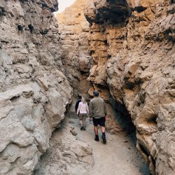
Slot Canyons
We began our day bright and early on a Saturday morning in January. We arrived at the slots around 8:30AM. We read a recommendation to start with the slots early morning as traffic through the canyon gets busier come late morning. The slots reminded me of a less bright orange/red version of Antelope Canyon; truly a hidden gem in the middle of the desert
Trailhead address: Borrego Mountain Wash, Anza-Borrego Desert State Park, Borrego Springs, CA 92004
Distance: 1 mile out & back (or 2.2 miles if you do the full loop)
Difficulty: Easy Total Ascent: 100 feet (or 330 feet if you do the full loop)
After Slot Canyon, we headed over to the Wind Caves. Wind Cave Trail is another short hike, about 1.25 miles round trip, taking you to these incredible rock formations with big holes that you can actually climb through. To get to the trail, you’re require to drive on a dirt road for about 4 miles. You will need a vehicle with 4-wheel drive. We drove in a Kia with 4WD and it was still very rocky and bumpy in some areas.
Trailhead address: Fish Creek Wash, Anza-Borrego Desert State Park, Borrego Springs, CA 92004
Distance: 1.25 miles out & back
Difficulty: Easy Total Ascent: 250 feet
Free parking
No dogs allowed
Processed with VSCO with e2 preset
Borrego Palm Canyon Trail
After the wind caves, we headed for our final hike of the morning, Borrego Palm Canyon Trail. If you ‘re familiar with Palm Springs, this trail, just like its name suggests, reminds me a lot of the Palm Canyon trail in Indian Canyons. It takes you to a neat palm oasis in the middle of the desert. My mom printed out this numbered guide that corresponded with 15 numbered markers along the trail that gave information on the surrounding area, which was fun to follow along with. To reach the trailhead, you must drive through the entrance of Borrego Palm Canyon Campground, which requires a $10 dollar fee. If you’ve already paid at the Slot Canyons, show the ranger and they’ll provide you with a pass, no extra charge.
Trailhead address: Borrego Palm Canyon Campground, Anza-Borrego Desert State Park, Borrego Springs, CA 92004
Distance: 3 miles out & back
Difficulty: Rate moderate Total Ascent: 300 feet
10 dollar parking fee
No dogs allowed
Lunch in Town
After our final hike of the day we head to the actual town of Borrego Springs to have lunch. We ate at a place called Carlee’s I believe?
Galleta Meadows
From there, we then drove over to the famous sculptures most often seen in pictures of Anza-Borrego. Artist/welder Ricardo Breceda, crafted over 130 metal sculptures scattered around the area. Interesting to say the least.
Fonts Point Overlook
Finally, we ended the day with an incredible view at Fonts Point Overlook. We almost missed it because again it required another 4 miles of off-roading and the directions we had were not correct. We had given up and were driving home when we saw the correct turn off sign and decided to go for it. Wow, was it so worth it. Here you’ll find an incredible overlook into the Borrego Badlands. People also say sunrise and sunset are spectacular there.
Address: From Christmas Circle in Anza Borrego, head out on S-22 for ten miles. Right after the 29-mile marker, you will see a dirt road on the right and a sign that says Font’s Point, 4 miles. This is where you will turn and start the off-roading to Font’s Point.
Distance: Requires a 4 mile drive on a dirt road to get there