Note: This post may contain affiliate links, meaning I get a commission if you decide to purchase something through the links, at no additional cost to you.
Located in Southern California in Thousand Palms near Palm Springs lies a hidden gem waiting to be discovered—the Coachella Valley Preserve. This unique sanctuary offers a captivating blend of desert beauty, biodiversity, and a rich cultural history, making it a must-visit destination for nature enthusiasts and curious wanderers alike. It’s a great place for families and kids too!
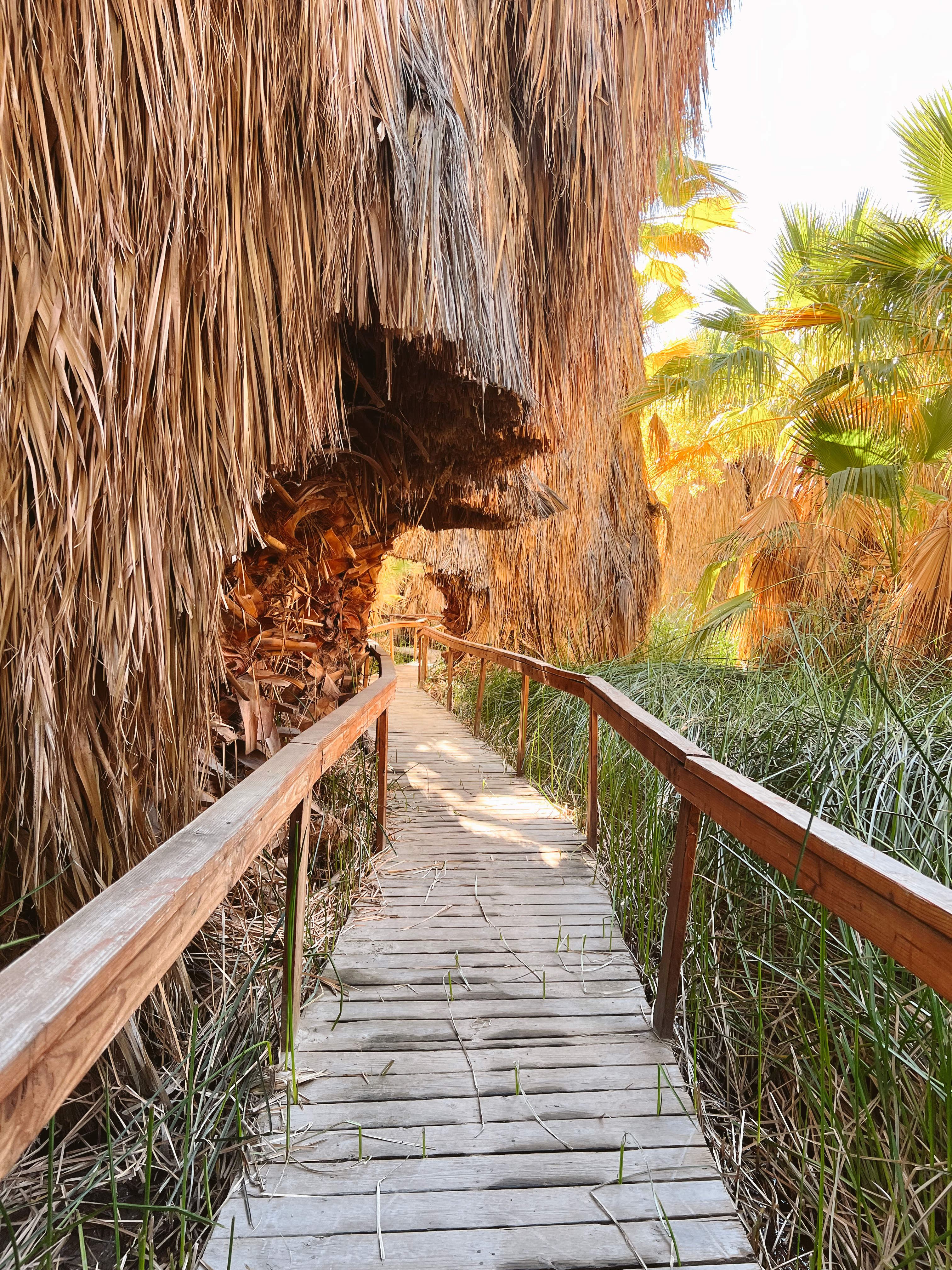
The Coachella Valley Preserve spans over 20,000 acres of pristine wilderness. The oasis in the Coachella Valley Preserve is primarily created because of the San Andreas Fault. This fault line extends for about 800 miles through California. The movement along the fault has led to the upward movement of underground water, creating natural springs. In the Thousand Palms Oasis within the preserve, the water emerging from these springs provides a lifeline to the California fan palms, creating a lush oasis in the midst of the dry desert landscape. The palms, in turn, provide shade and a more humid microclimate, attracting a variety of plant and animal species that have adapted to this unique environment.
Hiking Trails
Whether you’re looking for a leisurely stroll, an educational adventure for the kids to enjoy or a longer, more challenging hike, the Coachella Valley Preserve offers trails of all levels and experiences.
McCallum Trail:
1.8-mile out-and-back trail
95 ft. elevation gain
Rated easy
Pushawalla Palms Loop
4.4-mile loop trail
708 ft. elevation gain
Rated moderate
Moon Country Loop via McCallum Trail
3.7-mile loop trail
278 ft. elevation gain
Rated moderate
Hidden Palms Loop
1.9-mile loop trail
272. ft. elevation gain
Rated moderate
Hidden Horseshoe and Pushwalla Palms Trail
4.4-mile loop trail
554 ft. elevation gain
Rated Moderate
Hidden Palms to Horseshoe
3.3-mile loop
426 ft. elevation gain
Rated moderate
Willis Palm Loop
4-mile loop trail
531 ft. elevation gain
Rated moderate
Moon Country and Herman’s Hike via McCallum Trail
6.3-mile out-and-back trail
885 ft. elevation gain
Rated moderate
Múmawet Hill
0.7-mile loop
78 ft. elevation gain
Rated easy
Indian Palms Trail
1.2-mile out-and-back trail
111 ft. elevation gain
Rated easy
Remember to bring plenty of water! Also, be mindful that the summer months in the desert are frequently in the triple digits. It is recommended to hike from fall to spring.
Flora and Fauna
Beyond the mesmerizing palms, the Coachella Valley Preserve is home to a remarkable variety of plant and animal species. Native desert flora, including creosote bushes and wildflowers, paint the landscape with bursts of color, especially during the spring bloom. Keep a look out for small signs throughout that provide information on the native plants and animals that call the area home.
Cultural and Historical Significance
The preserve is not only a haven for nature enthusiasts but also a place of historical and cultural importance. The Agua Caliente Band of Cahuilla Indians, the indigenous people of the region, have a deep connection to the land. Petroglyphs and artifacts found in the area provide a glimpse into the ancient history of the Cahuilla people, adding a layer of cultural richness to the preserve.
The Coachella Valley Preserve in Thousand Palms, California, invites visitors to embark on a journey of discovery and appreciation for the beauty of the desert landscape. With its vibrant oasis, diverse wildlife, and rich cultural history, this preserve offers an enriching experience for those seeking a deeper connection with nature.
Whether you’re an avid hiker, a nature enthusiast, or simply looking to get the family out of the house for a bit, the Coachella Valley Preserve is a great choice. Happy exploring!
Murray Canyon Trail to Seven Sisters Waterfall is one of the most scenic and rewarding hikes in Palm Springs, California. This moderate hiking trail takes you through the Indian Canyons to a small hidden water fall payoff.
3.7 miles | Elevation gain 538 ft | Out & back | Rated Moderate
Indian Canyons is one of Palm Springs’ most breathtaking natural attractions, offering a rare blend of lush palm oases, flowing streams, rugged desert landscapes, and rich Native American history. Located on the ancestral land of the Agua Caliente Band of Cahuilla Indians, this protected area is home to some of the most scenic hiking trails in Southern California, including Palm Canyon, Andreas Canyon, and Murray Canyon.
The Trail:
The trail begins at the Indian Canyons Trading Post. Follow the signs guiding you towards Maynard Mine and Murray Canyon. Proceed south, crossing the dirt road over Andreas Canyon Creek. Once you’ve crossed, veer left immediately to stay on course toward Maynard Mine/Murray Canyon. Your journey unfolds along a road that winds through several picnic areas, shaded by beautiful arching palms. As you continue, you’ll eventually reach another trail sign and a map, marking the official trailhead for Murray and Maynard.
The path initially takes you through a desert landscape, along a dirt trail with not much shade but beautiful views of the surrounding mountains. Eventually the trail leads you down into Murray Canyon, guiding you along a creek through a lush palm oasis.
At the 1.5-mile mark, a connecting trail veers off to the left, leading upward towards the Coffman Trail on the ridge to the east. Keep right and continue on towards the Seven Sisters Waterfall. The next stretch is a bit more steep and rocky.
By the time you reach 1.9 miles, you’ll reach a final turn in the canyon towards the south, revealing the hidden gem—Seven Sisters Falls. It’s a small, tucked away flowing waterfall offering a moment of serenity; the perfect reward for conquering the journey.
Entry Fee: Be aware of the entry fees associated with your visit. Admission fees are as follows: Adults $12, Seniors 62+ $7, Students (with student ID) $7, Children (6-12) $6, Military (with U.S. military ID) Free, and Equestrian $11.
Respect Cultural Sites: The Indian Canyons hold cultural significance for the Cahuilla people. Respect the sacred sites, artifacts, and any cultural markers you encounter. Avoid touching or disturbing these elements.
Respect Wildlife: Indian Canyons is home to diverse wildlife. Observe animals from a distance, avoid feeding them, and respect their natural habitats.
Stay on Designated Trails: Stick to designated trails to protect the delicate desert ecosystem. Straying off the path can disturb plant life and contribute to erosion.
Check Trail & Weather Conditions: Before your visit, check the current trail conditions, as they can vary based on weather and maintenance. Stay informed about any closures or restrictions to ensure a smooth and safe experience. Also, be mindful that the summer months in Palm Springs are very hot and frequently in the triple digits. I would recommend doing this hike anytime from the fall through the spring.
So, there you have it—Murray Canyon to Seven Sisters Waterfall! Happy Hiking!
From lush oases to challenging peaks, here are the best hikes near Palm Springs!
Contents
Note: This post may contain affiliate links, meaning I get a commission if you decide to purchase something through the links, at no additional cost to you.
Whether you’re a seasoned hiker seeking a challenge or a casual adventurer looking to connect with nature, Palm Springs has a hike to suit your preferences. The surrounding mountains and canyons provide a plethora of hiking opportunities for outdoor enthusiasts of all skill levels. As a desert native and a hiking enthusiast, these are actually my top ten best hikes spanning across the entire Coachella Valley, not just in the city of Palm Springs. But, most people who aren’t from the desert, don’t recognize the name Coachella Valley, they are only familiar with where Palm Springs is so I decided to name the blog as such. Anyway, happy hiking!
There’s a small parking lot by Rim Road adjacent to a mobile home park. Please note that the trailhead isn’t actually in the mobile home park even though maps often make it look like it is. You will however, hike alongside it at the very beginning.
Araby Trail is definitely one of the most favored trails in the city of Palm Springs. Hikers are treated to breathtaking views of the surrounding mountains and a unique glimpse of the Bob Hope House, an architectural marvel. The trail is pretty much all uphill, covering a fair amount of elevation gain in just 1.7 miles, so be prepared, I definitely wouldn’t consider it an easy climb.
Tahquitz Canyon offers a perfect outing for families seeking a quick adventure. This easy to moderate hike takes you along ancient rock formations to a 60-foot waterfall payoff. Although it’s family-friendly, furry companions must stay home. Keep in mind the $15 per person fee ($7 for children aged 6-12) as it’s considered sacred land, owned by the Cahuilla Indians. An annual pass is available for $125. You also have to be 18 or older to enter the canyons alone. The park operates from Oct. 1 to July 4 from 7:30 a.m. to 5 p.m. daily (with the last hiker allowed on the trail at 3:30 p.m.).
Murray Canyon is located in the Indian Canyons between Palm Canyon and Andreas Canyon in the city of Palm Springs. The starting point of the trail is located at the same developed trailhead used for accessing Andreas Canyon. You may however, drive a short distance further into the picnic areas, which will trim a little less than 0.4 miles off the roundtrip distance. Please note that Indian Canyons does require an access fee, as it’s also considered sacred land, owned by the Cahuilla Indians. General admission for adults is $12.
This hike guides you along an easy desert terrain, offering views of sweeping vistas before leading you into the canyon where you’ll hike alongside a stream. The trail does cross over the stream multiple times, but for the most part, you shouldn’t get wet as there are rocks and logs guiding you over the water. I do recommend sturdy hiking boots or water shoes if you’re concerned about getting wet though. In the canyon, you’re also surrounded by lush vegetation and unique flora & fauna. The waterfall at the end of the trail is a wonderful payoff. Unlike the Tahquitz Canyon, 60-foot waterfall, Seven Sisters is much smaller and a bit tucked away, but still beautiful and refreshing.
The full Art Smith trail is a total of 16.2 miles and is considered challenging. But, if you’re looking to experience the beauty of this hike without committing to the full 16.2, consider doing Art Smith to the first oasis. It’s about 6 miles round trip, covering approximately 1,200 ft. total of elevation gain, leading to a small palm oases (shown below in the last image). The trailhead can be found off Highway 74, about 1/4 mile past the Bighorn Country Club. The best times to visit this trail are September through May. You’ll need to leave pups at home — dogs aren’t allowed on this trail.
Park at the unpaved lot located at the intersection of Avenida Bermudas and Calle Tecate. Follow the Cove Oasis Trail for 0.67 miles before turning left (you’ll see a Cove to Lake Trail sign). The first section of the trail is very flat but be prepared to walk aways in sand. As the trail progresses, expect moderate elevation changes. Hikers will experience stunning views of the Santa Rosa mountains and the nearby Quarry Golf Course. Eventually, the trail leads you to Lake Cahuilla, a small reservoir open for recreational fishing and camping.
Located at the eastern end of Avenue 42nd and the northern end of Golf Center Parkway in the city of Indio, the East Indio Badlands Trail offers a 5.2-mile loop showcasing a diverse array of geological formations, desert vegetation, and panoramic vistas of the Coachella Valley. The hike begins along the edge of the Terra Lago Resort Golf Course and leads you into a slot like canyon. Once out of the slots, you’ll experience a small accent with a nice payoff overlooking the entire desert. This trail is also very dog-friendly!
Begin your journey by driving to the Palm Springs Aerial Tram. Purchase your tram ticket and prepare for an exhilarating ride to the summit! The tram itself is a great experience, boasting the World’s Largest Rotating Tramcar. The Palm Springs Aerial Tramway travels over 2.5 miles up to the Mountain Station at 8,516 ft in just 10 minutes. The temperature at the Mountain Station is also 30 to 40 degrees cooler than the valley floor.
Once you make it up to the top of the tram, your next journey begins. The hike to San Jacinto Peak is 10.1 miles, out & back, covering 2,578 ft. of elevation gain. It’s no easy feat. The best times to visit this trail are March through November but check the weather conditions because depending on the winter, March may still be very snowy, with late storms blowing in. Also be sure to acquire a permit. Day-use permits can be obtained on the day of your trip by visiting the ranger station, which can’t be missed because you must past the ranger station to continue on the correct trail route.
The Bump-n-Grind Trail in Palm Desert is arguably the most popular hiking trail in the desert for locals looking for a good workout. The hike is known for its challenging incline and breathtaking views of the Coachella Valley. It’s a 4-mile loop that gains about 1,000 feet in elevation, making it a quick but intense workout (usually around 1 hour, depending on your fitness level).
This an easy 1.8 mile, out & back trail that’s great for kids and family! This trail features numbered stops providing insight into the surrounding fan palms, the San Andreas Fault, desert pupfish, and other geological and ecological wonders of the preserve.
For those looking for more information on the Coachella Valley preserve or other hiking trails to explore there, check out my blog, Exploring the Coachella Valley Preserve.
The Palm Desert Cross has definitely become a local landmark and one of the most popular hikes. It’s a fairly easy accent and it is dog-friendly. You can either do it as an out& back journey, turning it into about a 2.2 mile hike, or you can do the loop, extending it about an extra mile. The loop also takes you down to another hidden gem, the Yin Yang mural.
Honorable Mentions
Mission Creek Preserve – Desert Hot Springs
South & North Lykken Trail
Randall Henderson Loop – Palm Desert
Favorite areas just outside of the Coachella Valley
Whitewater Preserve
Ladder Canyon/Painted Canyon
Joshua Tree National Park
Morongo Valley Preserve
Whether you’re an avid hiker looking to conquer Cactus-to-Clouds or just looking to get out in nature at the Coachella Valley Preserve, I hope this round-up has helped you navigate your next adventure. Happy hiking my friends!
Cactus-to-Clouds is a 21-mile assent from the Palm Springs valley floor, starting at about 400 feet, up to the San Jacinto Peak at 10,834 feet. It is rated one of the hardest day hikes in the United States, and the trail actually has the largest elevation gain out of any hike in the United States. Skyline trail takes you up about 9.4 miles, starting behind the Palm Springs Art Museum and ascending to the top of the Palm Springs Aerial Tramway. Then, to do the full Cactus-to-Clouds hike, you continue for another 11 miles to the peak and back down to the tramway station to ride the tramcar back down to the valley floor.
WHAT TO PACK
Here is a list of everything I packed, with links to a few recommended essential items. I don’t gain any commission on any of these items, this is just exactly what I packed and what I would recommend (as a female hiker).
Layers, Layers, Layers – I wore biker shorts and a long sleeve dri-fit with a hat, which was perfect for the heat during the first half of the trek, and then I packed, sweatpants, a hoodie, a light windbreaker, and a larger warm jacket, a beanie, and mittens. By the time I reached the peak, I had every layer on and was so glad I packed it all.
Hiking Boots – I always recommend boots with ankle support for long hikes.
AT LEAST 1 Gallon of water – I brought three, 1.5 liter SmartWaters. Not the most environmentally friendly I know, but it was the most comfortable and cheap way I could think to pack them all on my back. I also packed four additional 16.9-ounce plastic water bottles that I had pre-prepared with the electrolyte and magnesium tablets ahead of time. I know most hikers use a bladder as well, which is also an option (I, for some reason, am not a huge fan). I packed all of this and still filled up two more of my SmartWaters at the Ranger Station at the top of the tram and completely drank both of those too by the end of the hike.
Snacks! – I cut up two protein bars into small bite-size pieces and put them in a baggie to snack on throughout the day. I’d also recommend some sort of salty snack like trail mix, crackers, etc. I also packed a peanut butter and honey sandwich, which is always my go-to trail food. It is recommended to try and eat something small every hour!
Hiking Backpack– Make sure it’s large enough to fit everything mentioned above (At least 35L)
Aside from what to pack, here’s a few other useful tips/information to consider.
Start at the Right Time – It is recommended you start this hike between 12 a.m. and 4:30 a.m. to allow yourself enough time to finish before the last tram car down at 9:30 p.m.
Hike During the Right Time of the Year – Fall is really the best season to do this hike so that the temperature isn’t too hot at the beginning and isn’t too cold as you reach the top. Temperatures in Palm Springs are in the triple digits during summer and temperates at the top of the Palm Springs Aerial Tramway are typically around 30 degrees in the winter with plenty of snow.
Pack AT LEAST 1 Gallon of Water – There are two rescue boxes along the trail that sometimes contain extra water left behind by other hikers, and you can also fill up at the ranger station at the top of the tramway, but I would definitely not rely on these sources, but they are good to know about beforehand in case of emergency. You will be hiking for many hours and need to be properly hydrated the day before the hike AND during the hike. Also, on that note, carb load the night before. I recommend a pasta night.
You Will Need a Permit – You must obtain a permit before continuing on once you reach the top of the tram. The permits are free and located at the ranger station. This not only allows rangers to protect the wilderness but is also meant to keep you safe. With limited cell service in the San Jacinto mountains, permits allow the rangers to know if you’ve safely returned from your hike.
Know Where to Park at the Trailhead – 101 N Museum Dr, Palm Springs, CA, 92262, USA. Do not park in the museum parking lot or the parking garage across the street or you will be ticketed (or worse, towed). There is however, free street parking around the museum with plenty of spots if you start early morning. Also keep in mind, you will be finishing the hike at the parking lot at the bottom of the Palm Springs Aerial Tramway, which is actually around 20 minutes from where you began your journey behind the Palm Springs Art Museum. Be sure to have a plan for how you will get back to your car.
THE ROUTE
Lastly, here are some trail markers that are helpful to know so you can see how far you’ve traveled and how many miles you still have left to go!
I hope this blog helps anyone out there looking to cross this beast of a hike off their bucket list. Happy hiking!
Nestled against the majestic San Jacinto Mountains in Southern California, lies sacred lands with a rich history—The Indian Canyons in Palm Springs. Managed by the Agua Caliente Band of Cahuilla Indians, these canyons are divided into three main hiking areas: Palm Canyon, Murray Canyon and Andreas Canyon. In this guide, we’ll explore some of the best hiking trails the region has to offer, other ways you can experience the area, and a few important “know before you go’s” to keep in mind before visiting.
Hiking Trails
Palm Canyon
Stretching for fifteen miles, Palm Canyon is home to one of the world’s largest fan palm oases. A moderately graded trail gently descends into the heart of the canyon, providing opportunities for picnics by the stream, exploration, invigorating hikes, or even leisurely horseback rides. For those seeking to delve deeper into the cultural richness of the area, a visit to the Trading Post is a must! Here, you can acquire hiking maps, enjoy refreshments, and explore a treasure trove of Indian art and artifacts including books, jewelry, pottery, baskets, weaving, and more.
Palm Canyon Trail:
Distance: Varies (up to 15 miles round trip).
Difficulty: Moderate to strenuous.
Highlights: As one of the world’s largest fan palm oases, Palm Canyon boasts breathtaking scenery. The trail allows hikers to explore the diverse flora and fauna, with the opportunity to witness the iconic California Fan Palms up close.
Victor Trail:
Distance: Approximately 1.5 miles round trip.
Difficulty: Moderate.
Highlights: Opt for the less-traveled Victor Trail for a secluded hiking experience. Panoramic views of the canyons and the surrounding desert make this trail a hidden gem.
Palm Canyon/Victor Loop:
Distance: Approximately 7 miles loop.
Difficulty: Strenuous.
Highlights: Combine the scenic beauty of Palm Canyon with the quieter Victor Trail on this challenging loop. The journey offers a comprehensive exploration of the Indian Canyons.
Fern Canyon Trail:
Distance: Approximately 2.5 miles round trip.
Difficulty: Moderate.
Highlights: Delve into the lush greenery of Fern Canyon, known for its fern-covered walls and shady ambiance. This trail adds a touch of enchantment to your Indian Canyons adventure.
Indian Potrero Trail:
Distance: Approximately 5 miles round trip.
Difficulty: Moderate.
Highlights: Indian Potrero Trail offers a longer trek through diverse landscapes, showcasing the unique flora and geological features of the canyons.
Hahn Buena Vista Trail:
Distance: Approximately 3 miles round trip.
Difficulty: Moderate.
Highlights: Hahn Buena Vista Trail provides panoramic vistas and a chance to appreciate the expansive desert scenery, making it a rewarding choice for hikers seeking stunning views.
West Fork Trail:
Distance: Approximately 7 miles round trip.
Difficulty: Moderate to strenuous.
Highlights: West Fork Trail offers a more extended journey through varied terrain, with opportunities to appreciate the diverse plant life and geological formations.
West Fork North Trail:
Distance: Approximately 4 miles round trip.
Difficulty: Moderate.
Highlights: West Fork North Trail provides a shorter but equally rewarding option, showcasing the beauty of the northern reaches of the Indian Canyons.
Jo Pond Trail:
Distance: Approximately 1.5 miles round trip.
Difficulty: Easy.
Highlights: Jo Pond Trail offers a leisurely stroll around a picturesque pond, providing a peaceful and family-friendly hiking option.
Vandeventer Trail:
Distance: Approximately 5 miles round trip.
Difficulty: Moderate.
Highlights: Vandeventer Trail takes hikers on a scenic journey with panoramic views, showcasing the vastness of the Indian Canyons.
East Fork Trail:
Distance: Approximately 5 miles round trip.
Difficulty: Moderate.
Highlights: East Fork Trail offers a captivating hike through varied landscapes, providing a mix of desert flora and geological formations.
Dry Wash Trail:
Distance: Approximately 4 miles round trip.
Difficulty: Moderate.
Highlights: The Dry Wash Trail offers a distinctive experience, winding through the dry washes of the canyons and providing a unique perspective of the surrounding desert landscape.
Andreas Canyon
Andreas Canyon oasis is home to vibrant green fan palms and over 150 plant types all within just a half-mile radius. A nice footpath takes you through the canyon, passing tall palms, interesting rocks, and the always-flowing Andreas Creek. You can still see old bedrock tools used for cooking centuries ago. This calm spot is great for taking photos, watching birds, or having a picnic at the trailside tables.
Andreas Canyon Trail:
Distance: Approximately 1 mile loop.
Difficulty: Easy.
Highlights: The main loop trail in Andreas Canyon takes you through a scenic route featuring vibrant wildflowers, diverse plant life, and the iconic California Fan Palms. It’s an easy stroll suitable for all ages.
Palm Canyon Trail Extension:
Distance: Approximately 2 miles round trip (including the extension).
Difficulty: Moderate.
Highlights: Extend your journey by connecting to the Palm Canyon Trail. This extension adds more distance and a slightly higher difficulty level, providing a deeper exploration of the canyon’s beauty.
Andreas Creek Bed Trail:
Distance: Varies (depending on exploration).
Difficulty: Easy to moderate.
Highlights: Follow the creek bed for a unique perspective of Andreas Canyon. This trail allows for a more immersive experience as you navigate through the canyon’s geological features and lush vegetation.
Maynard Mine Trail:
Distance: 6 miles roundtrip
Difficulty: Moderate.
Highlights: The Maynard Mine Trail offers a unique perspective, guiding you through the historic remnants of the Maynard Mine. Explore the geological features and learn about the area’s mining history on this moderately challenging trail.
Murray Canyon
Murray Canyon, just a bit south of Andreas Canyon, offers an easy to moderately challenging hikes. The trails, designed for both hikers and horseback riders, lead to picturesque recreation spots adorned with numerous palm trees. If you’re lucky, you might spot a Big Horn Sheep! It’s less visited than Palm Canyon or Andreas Canyon but offers its own secluded beauty.
Murray Canyon Loop Trail:
Distance: 5 mile loop.
Difficulty: Moderate.
Highlights: The Murray Canyon Loop Trail weaves through the diverse landscapes of Murray Canyon, combining various trails to offer a comprehensive and rewarding hiking experience.
Murray Canyon to Seven Sisters Trail:
Distance: approximately 4 miles, out & back
Difficulty: Moderate.
Highlights: The Seven Sisters Trail, with its interconnected pathways, takes you through captivating landscapes and offers opportunities to appreciate the beauty of nature within Murray Canyon.
Coffman Trail:
Distance: 1 ¼ miles
Difficulty: Moderate.
Highlights: Coffman Trail adds diversity to your hike, leading you through varied terrains and allowing you to explore the scenic wonders of Murray Canyon.
Alexander Trail:
Distance: 1¼ mile
Difficulty: Moderate.
Highlights: The Alexander Trail provides a pleasant trek through the canyon, offering a mix of natural beauty and a moderately challenging terrain.
Alexander East Trail:
Distance: 1½ mile
Difficulty: Moderate.
Highlights: Alexander East Trail adds an eastern perspective to your exploration, guiding you through unique features and enhancing your overall Murray Canyon experience.
Embark on a captivating adventure through the Indian Canyons with Red Jeep Tours. Traverse the rugged terrain of Palm Springs in a vibrant red Jeep, expertly guided by knowledgeable tour operators. From Andreas to Murray Canyon, let the vibrant red Jeep be your gateway to the wonders of this desert oasis, ensuring a memorable journey filled with awe-inspiring vistas and fascinating tales.
Discover the beauty of Palm Springs and Indian Canyons on a half-day tour from downtown Palm Springs, combining biking and hiking. This comprehensive experience includes a knowledgeable guide, bike rental, and snacks, making it effortlessly accessible to explore the stunning city and desert surroundings of southern California. Embark on a 10-mile (17-km) loop through Palm Springs to Indian Canyons, where you’ll then engage in a leisurely-paced hike within the canyon. Tailored for reasonably active individuals, this tour promises an immersive adventure through the captivating landscapes of Palm Springs and the Indian Canyons.
Embark on a unique equestrian adventure with Smoke Tree Stables! This horseback exploration invites you to connect with the desert landscape in a way that only a guided ride through the Indian Canyons can offer. With experienced guides leading the way, riders can immerse themselves in the natural wonders and cultural significance of this sacred land. Smoke Tree Stables not only provides a memorable journey through the canyons but also an opportunity to experience the rich heritage and diverse ecosystems of the Indian Canyons in a manner that resonates with the spirit of the Old West.
Know Before You Go
Entry Fee: Be aware of any entry fees associated with your visit. Ensure you have the necessary funds for admission, and check if there are any discounts available. Admission fees are as follows: Adults $12, Seniors 62+ $7, Students (with student ID) $7, Children (6-12) $6, Military (with U.S. military ID) Free, and Equestrian $11.
Plan Ahead: Plan your visit in advance, considering the time of year, weather, and the specific trails you want to explore. This ensures a more enjoyable and prepared adventure.
Respect Cultural Sites: The Indian Canyons hold cultural significance for the Cahuilla people. Respect the sacred sites, artifacts, and any cultural markers you encounter. Avoid touching or disturbing these elements.
Respect Wildlife: Indian Canyons is home to diverse wildlife. Observe animals from a distance, avoid feeding them, and respect their natural habitats. Binoculars can enhance your wildlife-watching experience.
Hydration is Key: Southern California’s desert climate can be deceptively dry. Bring an ample supply of water to stay hydrated, especially if you’re planning an extended hike. It’s crucial to combat the arid conditions.
Wear Appropriate Clothing: Dress in layers and wear comfortable, breathable clothing suitable for the desert environment. Sturdy hiking shoes are recommended for trails with varying terrains.
Sun Protection: Shield yourself from the sun’s intensity by wearing a wide-brimmed hat, sunglasses, and sunscreen. Protecting your skin and eyes is crucial in the desert sun.
Pack Snacks: Bring light snacks to keep your energy levels up during your exploration. Portable, non-perishable snacks are convenient for a quick refuel.
Stay on Designated Trails: Stick to designated trails to protect the delicate desert ecosystem. Straying off the path can disturb plant life and contribute to erosion.
Check Trail Conditions: Before your visit, check the current trail conditions, as they can vary based on weather and maintenance. Stay informed about any closures or restrictions to ensure a smooth and safe experience.
As you embark on your journey through the Indian Canyons, you’ll discover not only the breathtaking natural beauty of the desert landscape but also the rich cultural tapestry woven by the indigenous people who have called this region home for centuries. Immerse yourself in the stories of Andreas Canyon, marvel at the palm oases, and find tranquility in the heart of nature. The Indian Canyons offer a unique and enriching experience that will leave you with memories to last a lifetime. Happy exploring!


